Mayotte
| Dä Artikel bhandlet d Inselgruppe zwüsche Afrika und Madagaskar. Wyteri Bedütige vo „Mayotte“ findsch doo. |
| Basisdate | |
|---|---|
| Amtssprooch | Französisch |
| Hauptort | Mamoudzou |
| Flechi | 374 km² |
| Iiwohner | 256.518 (14. Dezember 2017)[1] |
| Bevölkerigsdichti | 686 Iiwohner pro km² |
| Kanton | 13 |
| Gmeinde | 17 |
| Präfekt | Frédéric Veau |
| Presidänt vom Regionalroot | Soibahadine Ibrahim Ramadani |
| Währig | Euro (€) 1 Euro = 100 Cent |
| Zitzone | UTC+3 |
| Internet-TLD | .yt |
| Vorwahl | +262 |
| Charte | |

| |
 | |
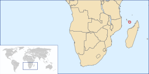
Mayotte isch en Inselgruppe zwüsche Afrika und Madagaskar; politisch isch s e französischs Überseegebiet.
Ab 1976 isch es e Gebietskörperschaft vo dr Französische Republik (Collectivité territoriale de la République française, sit 2001 under dr Bezeichnig Collectivité départementale) gsi. Im Merz 2011 het Mayotte dr Status vom ene französische Überseedepartement bechoo und isch drmit Deil vo dr Europäischen Union worde. Mayotte lit am nördlige Rand vo dr Strooss vo Mosambik im Indischen Ozean zwüschen em nördlige Deil vo Madagaskar und em Norde vo Mosambik. Geografisch ghört s zum Archipel vo de Komore.
Geographii
[ändere | Quälltäxt bearbeite]

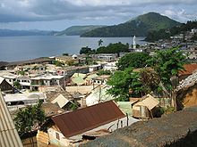
D Inselgruppe Mayotte bestoht us dr Hauptinsle „Grande Terre“ (wo mn em au wie em ganze Überseegebiet sälber Mayotte sait), dr Näbeninsle „Petite Terre“ (Pamanzi) und mehrere chliinere und unbewohnte Insle (îlots). D Landflechi bedräit öbbe 374 km². Mayotte isch mit em ene Alter vo öbbe 9 Millione Johr die eltisti Vulkaninsle vo de Komore. Um d Insle ume het s Koralleriff. In dr Rägezit vom Novämber bis Merz si d Tämprature höcher as in dr Drochezit. Dr höchsti Punkt isch dr Mont Benara uf dr Hauptinsle mit 660 Meter. D Hauptstadt Mamoudzou lit ebefalls uf dr Hauptinsle, während dr internationali Flughafe Dzaoudzi uf Petite Terre lit.
Bevölkerig
[ändere | Quälltäxt bearbeite]Vo 160.301 Iiwohner si noch em Zensus vo 2002 64,7 % uf Mayotte uf d Wält cho, 3,9 % in andere französische Gebiet. 28,1 % si vo de benochberte unabhängige Komoreninsle iigwanderet, 2,8 % us Madagaskar und die übrige 0,5 % us andere Länder.[2] Im Juli 2004 het mä 178.438 Iiwohner zehlt, wo meh as d Helfti drvo jünger as 20i gsi si.
98 % vo dr Bevölkerig si sunnitischi Muslime. D Amtssprooch isch zwar Französisch, gschwätzt wird aber vor allem Mahorisch, e Variante vom Komorische, wo äng mit em Swahili verwandt isch.
Bis zum ene Drittel vo de Iiwohner (70.000 vo 200.000 im Johr 2007) si illegali Iiwanderer vo de ermere Nochberinsle, wo in Boot, wo kwassa-kwassa heisse, d Überfahrt uf Mayotte gwogt hai, zum do under herte Bedingige, aber zu wäsentlig attraktivere Löhn as dehei uf Plantage z schaffe.[3]
Fuessnote
[ändere | Quälltäxt bearbeite]- ↑ Französisches Statistikinstitut (www.insee.fr)
- ↑ MIG 1 DET – POPULATION SELON LE LIEU DE NAISSANCE
- ↑ Spiegel Special: Afrika – Das umkämpfte Paradies, „Das Insel-Labor“ vom 22. Mai 2007
Weblingg
[ändere | Quälltäxt bearbeite]- CIA World Factbook: Mayotte (englisch)
- dw-Reportage über d Iiwanderig uf Mayotte
- «Voyages … Visages» − Eine andere Art zu reisen und zu sehen
- „Europa im Indischen Ozean - Die Insel Mayotte wird das 101. französische Departement“, Feature vom Dütschlandfunk vom 11. Dezember 2010 (Abschrift als PDF)
- Insel Mayotte wird zum 101. französischen Departement Artikel vo dr Französische Botschaft z Berlin
| |||
|
France métropolitaine : | |||
|
Iww´rseeregione : | |||
|
France métropolitaine bis 2016 : |
Koordinate: 12° 51′ S, 45° 8′ O


