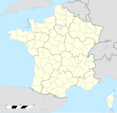
Kerfourn
Erscheinungsbild
| Kerfourn | |
 | |
| Verwàltung | |
|---|---|
| Land | |
| Region | |
| Département | Morbihan (56) |
| Arrondissement | Pontivy |
| Kànton | Pontivy |
| Kommünàlverbànd | Pontivy Communauté |
| Àmtliga Nàma | Kerfourn |
| Maire | Joël Marivain (2014-2020)[1] |
| Code Insee | 56092 |
| Poschtlaitzàhl | 56920 |
| Iiwohner | |
| Iiwohner | 831 |
| Flech | 19,46 km2 |
| Bevelkerungsdicht | 42,45 Iiw./km2 |
| Làg | |
| Koordinate | 48° 02′ 35″ N, 2° 50′ 00″ W / 48.043055555556°N,2.8333333333333°WKoordinate: 48° 02′ 35″ N, 2° 50′ 00″ W / 48.043055555556°N,2.8333333333333°W |
| Heche | 123 m |
| Website | |
| http://kerfourn.fr | |
Kerfourn (bretonisch Kerforn) isch e franzesischi Gmai im Département Morbihan in dr Region Bretagne.
D Gmai ghert zum Kanton Pontivy un zum Arrondissement Pontivy.
Geografi
[ändere | Quälltäxt bearbeite]Kerfourn lyt 43 km vu Vannes un 52 km vu Lorient uf ere Hechi zwische 92 m un 138 m iber Normalnull. D Nochbergmaine sin Noyal-Pontivy im Weschte, Gueltas im Nordoschte, Crédin im Oschte un Naizin im Side.
Gschicht
[ändere | Quälltäxt bearbeite]Kerfourn isch zum erschte Mol gnännt wore anne 1461 as Kerforn. Im Johr 1839 isch s Dorf e aigeständigi Gmai wore, scho 1802 isch d Bfarrei sälbständig wore.
Verwaltig
[ändere | Quälltäxt bearbeite]Dr Maire vu Kerfourn isch dr Joël Marivain. Kerfourn ghert zum Kommunalverband Pontivy Communauté.
Bevelkerigsentwicklig
[ändere | Quälltäxt bearbeite]| Johr | 1962 | 1968 | 1975 | 1982 | 1990 | 1999 | 2008 |
| Yywohner | 769 | 765 | 713 | 731 | 773 | 724 | 813 |
Dialekt
[ändere | Quälltäxt bearbeite]Dr traditionell Dialäkt vu Kerfourn ghert zum Bretonisch.
Böuwärch
[ändere | Quälltäxt bearbeite]- Chilche Saint-Eloi (1896-99)
Weblink
[ändere | Quälltäxt bearbeite]- https://web.archive.org/web/20180905171912/http://www.kerfourn.fr/
- Kerfourn uf geobreizh.com (Internet-Archive)
Fueßnote
[ändere | Quälltäxt bearbeite]- ↑ Liste des maires au 25 avril 2014 (data.gouv.fr)

