
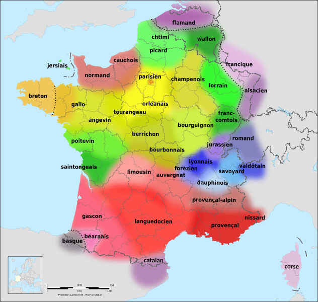
Datei:Langues de la France.svg

Gröössi vor PNG-Vorschou vor SVG-Datei: 632 × 600 Pixel. Wyteri Ufflösige: 253 × 240 Pixel | 506 × 480 Pixel | 809 × 768 Pixel | 1.079 × 1.024 Pixel | 2.158 × 2.048 Pixel | 2.000 × 1.898 Pixel.
Originaldatei (SVG-Datei, Basisgrößi: 2.000 × 1.898 Pixel, Dateigrößi: 1,18 MB)
| Die Datei un d Informatione derzue were us em zäntrale Mediearchiv Wikimedia Commons (Allmänd) iibunde. | Zur Bschriibigssite uff de Allmänd |
Bschryybig
| Bschryybig |
|
| Datum | (UTC) |
| Quälle | |
| Urheber |
|
| Anderi Versione |
[] |
| SVG‑Erstellung |
Lizänzierig
Die Datei isch lizänziert unter dr Creative-Commons-Lizenz Namensnännig – Wytergab unter glyche Bedingige 3.0 nit portiert.
- Du derfsch:
- des Wärch an anderi wytergee – des Wärch kopiere, verbreite un ibertrage
- des Wärch verändere – des Wärch aapasse
- Unter däne Bedingige:
- Namenännig – Du muesch aagmässeni Aagabe zum Urheber un dr Rächt mache, e Link zue dr Lizänz zuefiege un aagee, eb Änderige gmacht wore sin. Die Aagabe chenne in ere aagmässene Art gmacht wäre, aber nit eso, ass dr Yydruck entstoht, ass dr Lizänzgeber Dii oder Dyy Gebruch vum Wärch unterstitze un guetheiße.
- Wytergab unter glyche Bedingige – Wänn du des Wärch veränderesch, umwandlesch oder druf ufböusch, no derfsch s Ergebnis nume unter dr glyche oder ere kumpatible Lizänz wie s Orginal vereffetlige.
Orginal Logbuech vu uffegladene Datei
This image is a derivative work of the following images:
- File:Langues de la France1.gif licensed with Attribution
- 2009-11-11T07:57:53Z Parigot 603x599 (178168 Bytes) Colorisation du saintongeais.
- 2008-01-21T20:48:21Z Parigot 603x599 (179774 Bytes) Finalisation des retouches géo-linguistiques
- 2008-01-21T20:35:50Z Parigot 603x599 (179708 Bytes) {{Information |Description= |Source= |Date= |Author= |Permission= |other_versions= }}
- 2008-01-21T20:31:20Z Parigot 603x599 (179708 Bytes) Modification poitevin et saintongeais
- 2008-01-21T20:22:56Z Parigot 603x599 (179683 Bytes) Modification des limites linguistiques poitevine et saintongeaise.
- 2008-01-20T18:38:48Z Parigot 603x599 (179753 Bytes) Carte des langues régionales.
- 2007-08-12T10:05:05Z Parigot 654x650 (123918 Bytes) Nouvelle version fichier image. Ajout parler angevin
- 2007-08-12T10:02:48Z Parigot 654x650 (123918 Bytes) Nouvelle version du fichier avec ajout du parler angevin
- 2007-08-12T10:02:05Z Parigot 654x650 (123918 Bytes) Nouvelle version du fichier avec ajout du parler angevin
- 2007-08-12T09:58:26Z Parigot 654x650 (123918 Bytes) Nouvelle version du fichier avec ajout du parler angevin
- 2006-11-30T12:19:15Z Yug 654x650 (37578 Bytes) improved : Occitan => Languedocien
- 2006-11-18T02:26:22Z Chlämens 654x650 (38730 Bytes)
- 2006-07-27T12:53:36Z Moyogo 654x650 (37081 Bytes) removed québécois - title says 'Languages of France'.
- 2005-04-03T11:12:50Z Chlämens 654x650 (46252 Bytes)
- File:Départements de France-simple.svg licensed with PD-self
- 2007-09-09T11:49:17Z Marmelad 507x553 (148302 Bytes) added a box zoomed in around Paris to show the small departements near the city, as in [[:Image:Carte France Département 95.png]] (currently hidden). For documentation on how to use this image, see [[:User:Marmelad/FRA-Map
- 2007-09-08T17:06:31Z Marmelad 507x553 (147117 Bytes) Cleaned up the svg code for use with auto-generating software.
- 2007-04-24T09:27:36Z Emmanuel.boutet 507x553 (184098 Bytes) {{Information |Description=Version simplifiée de [[:Image:Départements et régions de France.svg]] |Source=[[:Image:Départements et régions de France.svg]] by [[User:bayo|bayo]] |Date=2007-04-24 |Author=[[User:Emmanuel.bo
- File:France map Lambert-93 with regions and departments-blank.svg licensed with PD-self
- 2008-11-13T19:38:00Z by Sting 2000×1898 (865 Kio)
Hochgeladen mit derivativeFX
Dateiversione
Klick uf e Zytpunkt zu aazeige, wie s dert usgsäh het.
| Version vom | Vorschaubild | Mäß | Benutzer | Kommentar | |
|---|---|---|---|---|---|
| aktuell | 16:18, 22. Feb. 2022 | | 2.000 × 1.898 (1,18 MB) | Eowyn Cwper | Added language family separator; minor label improvements and corrections |
| 01:08, 24. Feb. 2010 |  | 2.000 × 1.898 (1,21 MB) | Hellotheworld | {{en|(almost?) final version of the file, changing the Font to 'DejaVu' (improving MediaWiki compatibility)+ improving colors for better readeability}} {{fr|version (presque ?) finale du fichier, changement de la police pour 'DejaVu' (ce qui améliore la | |
| 00:46, 19. Feb. 2010 |  | 2.000 × 1.898 (1,21 MB) | Hellotheworld | minor modification. {{en|blur improvment.}} {{fr|amélioration du flou sur les zones linguistiques}} | |
| 22:50, 18. Feb. 2010 |  | 2.000 × 1.898 (1,21 MB) | Hellotheworld | suppressing a little (boring) bug of 'text melting'... | |
| 22:39, 18. Feb. 2010 |  | 2.000 × 1.898 (1,21 MB) | Hellotheworld | {{New major update, still thanks to the Atelier Graphique... using a 'big and clean SVG original file'}} {{Nouvelle évolution majeure, toujours grâce à l'Atelier Graphique, en utilisant une 'grosse et belle image SVG originale')}} | |
| 20:52, 18. Feb. 2010 |  | 507 × 553 (246 KB) | Hellotheworld | ??? ... Same player shoot again. {{fr|(on réessaye !)}} | |
| 20:50, 18. Feb. 2010 |  | 507 × 553 (246 KB) | Hellotheworld | {{fr|Amélioration majeure suite à des remarques pertinentes de l'Atelier Graphique : ajout de la mer, correction des erreurs typographiques, mise en relief du texte, "floutage" du contour des bulles...}} {{en|Major improve, next to french Atelier Graphi | |
| 02:03, 18. Feb. 2010 |  | 507 × 553 (220 KB) | Hellotheworld | {{fr|suppression du fichier BMP source, qui sert... de source, mais plante MédiaWiki}} {{en|suppressing the original BMP file, wich is... the original file, mais bugs MediaWiki}} | |
| 20:42, 17. Feb. 2010 |  | 507 × 553 (224 KB) | Hellotheworld | {{en|Finished work.}} {{fr|Fichier terminé.}} | |
| 19:27, 17. Feb. 2010 |  | 507 × 553 (189 KB) | Hellotheworld | {{en|WORK IN PROGRESS. Solved problem of "black text". This file is in progress, I created it early to not loose the sources, according to licence.}} {{fr|TRAVAIL EN COURS. Problème résolu pour les "texte en noir". Ce fichier est en cours de travail, je |
Verwändig vu dr Datei
Di folgende Sytene händ en Link zu dem Bildli:
Wältwyti Dateinutzig
Die andere Wikis bruche die Datei:
- Gebruch uf af.wikipedia.org
- Gebruch uf ar.wikipedia.org
- Gebruch uf ast.wikipedia.org
- Gebruch uf bn.wikipedia.org
- Gebruch uf br.wikipedia.org
- Gebruch uf ca.wikipedia.org
- Gebruch uf co.wikipedia.org
- Gebruch uf da.wikipedia.org
- Gebruch uf de.wikipedia.org
- Gebruch uf el.wiktionary.org
- Gebruch uf en.wikipedia.org
- Gebruch uf eo.wikipedia.org
- Gebruch uf es.wikipedia.org
- Gebruch uf eu.wikipedia.org
- Gebruch uf fa.wikipedia.org
- Gebruch uf fi.wikipedia.org
- Gebruch uf frp.wikipedia.org
- Gebruch uf frr.wikipedia.org
- Gebruch uf fr.wikipedia.org
Wältwyti Verwändig vu däre Datei aaluege.