Datei:Map of territorial growth 1775.jpg

Seiteninhalte werden in anderen Sprachen nicht unterstützt.
Us der alemannische Wikipedia, der freie Dialäkt-Enzyklopedy

Originaldatei(570 × 750 Pixel, Dateigrößi: 172 KB, MIME-Typ: image/jpeg)

Die Datei un d Informatione derzue were us em zäntrale Mediearchiv Wikimedia Commons (Allmänd) iibunde. Zur Bschriibigssite uff de Allmänd Zur Bschriibigssite uff de Allmänd
Please translate the English parts of this template into Alemannisch.
Säll Bild gitt's au in als Vektorgrafik (SVG). Wenn's besser isch, no benutz säll anstell vu dem Rasterbild.

File:Map of territorial growth 1775.jpg → File:Map of territorial growth 1775.svg

Meh zu Vektorgrafike findsch unter Wechsel zu SVG.
Zu de Unterstützig vu SVG durch d'MediaWiki-Software lüeg unter SVG image support uff Meta.

In other languages ([//commons.wikimedia.org/w/index.php?title=Template:In_other_languages&action=edit translate this])
Alemannisch  Bahasa Indonesia  Bahasa Melayu  British English  català  čeština  dansk  Deutsch  eesti  English  español  Esperanto  euskara  français  Frysk  galego  hrvatski  Ido  italiano  lietuvių  magyar  Nederlands  norsk bokmål  norsk nynorsk  occitan  Plattdüütsch  polski  português  português do Brasil  română  Scots  sicilianu  slovenčina  slovenščina  suomi  svenska  Tiếng Việt  Türkçe  vèneto  Ελληνικά  беларуская (тарашкевіца)  български  македонски  нохчийн  русский  српски / srpski  татарча/tatarça  українська  ქართული  հայերեն  বাংলা  தமிழ்  മലയാളം  ไทย  한국어  日本語  简体中文  繁體中文  עברית  العربية  فارسی  +/−
S neu SVG-Bild

Bschryybig

Bschryybig
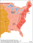
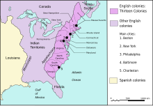
Deutsch: Östliches Nordamerika im Jahre 1775 mit der vom Königreich Großbritannien kontrollierten Provinz Quebec und den dreizehn Kolonien an der Küste sowie dem von diesen durch die Proklamationslinie von 1763 abgeschiedene Indian Reserve (siehe auch: Britische Kolonisierung Amerikas).
English: Eastern North America in 1775: The map shows part of the British Province of Quebec, the British thirteen colonies on the Atlantic coast, the interior Indian Reserve, and parts of New Spain. Some colonies claimed land further west, but only the areas shown in red were legally open to settlement by European-Americans, due to the Royal Proclamation of 1763). East Florida and West Florida had been acquired by Britain from Spain, and did not join the American Revolution the next year.
Italiano: Nel 1775, l'Inghilterra aveva il dominio sulle zone indicate in rosso e rosa sulla mappa e la Spagna su quelle arancione. La zona rossa è quella relativa alle 13 colonie aperte agli insediamenti dopo la proclamazione del 1763.
Datum
Quälle National Atlas of the United States via en.wikipedia
Urheber see below
Gnähmigung
(Wyternutzig vu däre Datei)
Public domain
Diese Karte stammt aus einer Ausgabe des National Atlas of the United States. Wie fast alle Arbeiten der Regierung der Vereinigten Staaten sind Arbeiten des National Atlas in den USA gemeinfrei.
Online-Zugang: NationalAtlas.gov | Gedruckte Ausgabe von 1970: Library of Congress, Perry-Castañeda Library

čeština | Deutsch | English | français | Bahasa Indonesia | italiano | македонски | മലയാളം | sicilianu | 中文 | 中文(简体)‎ | 中文(繁體)‎ | +/−

Anderi Versione
File:Map Thirteen Colonies 1775-fr.svg
File:Map of territorial growth 1775.svg

Kurzbeschreibungen

Ergänze eine einzeilige Erklärung, was diese Datei darstellt.

In dieser Datei abgebildete Objekte

Motiv

Dateiversione

Klick uf e Zytpunkt zu aazeige, wie s dert usgsäh het.

Version vomVorschaubildMäßBenutzerKommentar
aktuell05:07, 30. Mär. 2013Vorschaubild fir Version vum 05:07, 30. Mär. 2013570 × 750 (172 KB)Ras67cropped
06:44, 3. Dez. 2006Vorschaubild fir Version vum 06:44, 3. Dez. 2006620 × 800 (122 KB)Dedee73The first 13 american colonies
23:13, 6. Jun. 2005Vorschaubild fir Version vum 23:13, 6. Jun. 2005620 × 800 (122 KB)KoomaMap of territorial growth, 1775. From en.wiki. {{PD-USGov-Atlas}} Category:American Revolution

Kei Artikel bruucht die Datei.

Wältwyti Dateinutzig

Die andere Wikis bruche die Datei:

Wältwyti Verwändig vu däre Datei aaluege.

Metadate