
Datei:France, administrative divisions - de (+overseas) - colored 2016.svg

Gröössi vor PNG-Vorschou vor SVG-Datei: 624 × 600 Pixel. Wyteri Ufflösige: 250 × 240 Pixel | 499 × 480 Pixel | 799 × 768 Pixel | 1.066 × 1.024 Pixel | 2.131 × 2.048 Pixel | 2.000 × 1.922 Pixel.
Originaldatei (SVG-Datei, Basisgrößi: 2.000 × 1.922 Pixel, Dateigrößi: 1,81 MB)
| Die Datei un d Informatione derzue were us em zäntrale Mediearchiv Wikimedia Commons (Allmänd) iibunde. | Zur Bschriibigssite uff de Allmänd |
Bschryybig


.svg)


_(Paris_zoom).svg)
.svg)
,_administrative_divisions_-_de_-_colored_(multizoom).svg)
_-_colored.svg)
.svg)
,_administrative_divisions_-_Nmbrs_(multizoom).svg)
,_administrative_divisions_-_de_-_colored.svg)
_-_de_-_colored.svg)

.svg)

.svg)
_-_colored_2016.svg?uselang=als)
Lizänzierig
Ich haa s Urheberrächt an däm Wärch un vereffetlig s dodermit unter däre Lizänz:
Die Datei isch lizänziert unter dr Creative-Commons-Lizänz Namensnännig – Wytergab unter glyyche Bedingige 3.0 Dytschland.
- Du derfsch:
- des Wärch an anderi wytergee – des Wärch kopiere, verbreite un ibertrage
- des Wärch verändere – des Wärch aapasse
- Unter däne Bedingige:
- Namenännig – Du muesch aagmässeni Aagabe zum Urheber un dr Rächt mache, e Link zue dr Lizänz zuefiege un aagee, eb Änderige gmacht wore sin. Die Aagabe chenne in ere aagmässene Art gmacht wäre, aber nit eso, ass dr Yydruck entstoht, ass dr Lizänzgeber Dii oder Dyy Gebruch vum Wärch unterstitze un guetheiße.
- Wytergab unter glyche Bedingige – Wänn du des Wärch veränderesch, umwandlesch oder druf ufböusch, no derfsch s Ergebnis nume unter dr glyche oder ere kumpatible Lizänz wie s Orginal vereffetlige.


|
Wenn du die Datei außerhalb der Wikipedia oder Commons verwendest, begrüße ich es, wenn du als Quelle Wikimedia Commons angeben könntest. Wenn du die Datei in einem Buch, Zeitung, Blog, Webseite, etc. verwendest, füge bitte hier folgende Zeile ein:
|
_-_colored_2016.svg)
Dateiversione
Klick uf e Zytpunkt zu aazeige, wie s dert usgsäh het.
| Version vom | Vorschaubild | Mäß | Benutzer | Kommentar | |
|---|---|---|---|---|---|
| aktuell | 22:13, 9. Dez. 2016 | | 2.000 × 1.922 (1,81 MB) | Chumwa | neue Regionsnamen sind festgelegt |
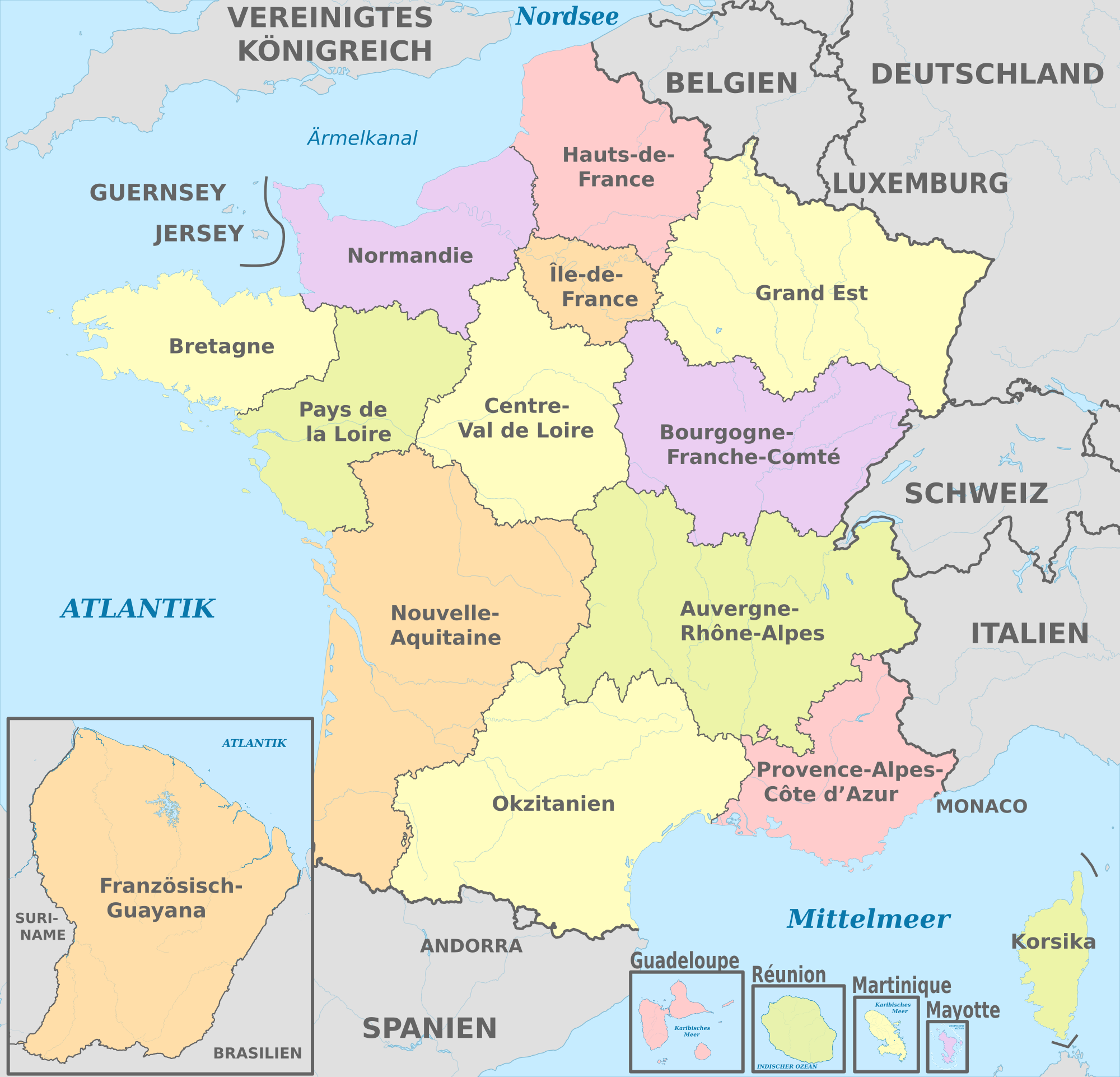
| 16:15, 28. Dez. 2015 |  | 2.000 × 1.922 (1,84 MB) | TUBS | == {{int:filedesc}} == {{Information |Description={{de|Karte der politischen Gliederung von Frankreich ab 1. Januar 2016 (Arbeitsnamen)}} {{en|Map of administrative divisions of France since 1st Jan 2016 (working titles)}} |Source={{own}}{{Adobe Illus... |
Verwändig vu dr Datei
Di folgende Sytene händ en Link zu dem Bildli:
Wältwyti Dateinutzig
Die andere Wikis bruche die Datei:
- Gebruch uf de.wikipedia.org
- Gebruch uf es.wikipedia.org
- Gebruch uf frr.wikipedia.org
- Gebruch uf it.wikipedia.org
- Gebruch uf lv.wikipedia.org
- Gebruch uf sl.wikipedia.org
- Gebruch uf to.wikipedia.org
_-_colored_2016.svg)