
Datei:Corse region relief location map.jpg

Greßi vu däre Vorschau: 304 × 600 Pixel. Wyteri Ufflösige: 121 × 240 Pixel | 243 × 480 Pixel | 824 × 1.625 Pixel.
Originaldatei (824 × 1.625 Pixel, Dateigrößi: 324 KB, MIME-Typ: image/jpeg)
| Die Datei un d Informatione derzue were us em zäntrale Mediearchiv Wikimedia Commons (Allmänd) iibunde. | Zur Bschriibigssite uff de Allmänd |
Bschryybig
| Kameraposition | | Dieses und weitere Bilder auf OpenStreetMap |
|---|
| Bschryybig |
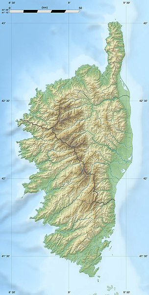
English: Blank physical map of the region of Corsica, France, for geo-location purpose, with distinct boundaries for departments and arrondissements as they are since January 2010.
The former version of the map shows the boundaries as they were until December 2009. Français : Carte physique vierge de la région Corse, France, destinée à la géolocalisation, avec limite distincte des départements et arrondissements tels que depuis janvier 2010. L'ancienne version de la carte montre le découpage administratif tel qu'il était jusqu'en décembre 2009. Scales: 1:520,000 (precision: 130 m) for the topography; 1:7,420,000 (precision: 1,855 m) for the bathymetry
Geographic limits of the map:
|
||
| Datum | 2008-08, modified 02-2010 | ||
| Quälle |
Eigeni Arbet
|
||
| Urheber | Eric Gaba (Sting - fr:Sting) | ||
| Gnähmigung (Wyternutzig vu däre Datei) |
|
||
| Anderi Versione |
|

Lizänzierig
Ich haa s Urheberrächt an däm Wärch un vereffetlig s dodermit unter däne Lizänze:
Die Datei isch lizänziert unter dr Creative-Commons-Lizenz Namensnännig – Wytergab unter glyche Bedingige 3.0 nit portiert.
- Du derfsch:
- des Wärch an anderi wytergee – des Wärch kopiere, verbreite un ibertrage
- des Wärch verändere – des Wärch aapasse
- Unter däne Bedingige:
- Namenännig – Du muesch aagmässeni Aagabe zum Urheber un dr Rächt mache, e Link zue dr Lizänz zuefiege un aagee, eb Änderige gmacht wore sin. Die Aagabe chenne in ere aagmässene Art gmacht wäre, aber nit eso, ass dr Yydruck entstoht, ass dr Lizänzgeber Dii oder Dyy Gebruch vum Wärch unterstitze un guetheiße.
- Wytergab unter glyche Bedingige – Wänn du des Wärch veränderesch, umwandlesch oder druf ufböusch, no derfsch s Ergebnis nume unter dr glyche oder ere kumpatible Lizänz wie s Orginal vereffetlige.

|
Des Dokumänt derf kopiert, verbreitet un/oder bearbeitet wäre unter dr Bedingige vu dr GNU-Lizänz fir freji Dokumäntation, Version 1.2 oder ere spetere Version, vereffetligt dur Free Software Foundation. S het keini uuveränderlige Abschnitt, kei vordere Umschlagstext un kei hindere Umschlagstext. E Kopii vu dr Lizänz isch verfiegbar im Abschnitt GNU-Lizänz fir freji Dokumäntation. |
Du chasch sälber e Lizänz uuswehle.
Dateiversione
Klick uf e Zytpunkt zu aazeige, wie s dert usgsäh het.
| Version vom | Vorschaubild | Mäß | Benutzer | Kommentar | |
|---|---|---|---|---|---|
| aktuell | 15:50, 18. Jul. 2010 | | 824 × 1.625 (324 KB) | Sting | Color profile |
| 20:33, 22. Feb. 2010 |  | 824 × 1.625 (317 KB) | Sting | Updated arrondissments boundaries of Haute-Corse | |
| 21:50, 14. Aug. 2008 |  | 824 × 1.625 (315 KB) | Sting | == Summary == {{Location|42|12|00|N|09|03|00|E|scale:2000000}} <br/> {{Information |Description={{en|Blank physical map of the region of Corsica, France, for geo-location purpose, with distinct boundaries for departments and arrondissement |
Verwändig vu dr Datei
Di folgende Sytene händ en Link zu dem Bildli:
Wältwyti Dateinutzig
Die andere Wikis bruche die Datei:
- Gebruch uf ang.wikipedia.org
- Gebruch uf ar.wikipedia.org
- Gebruch uf ast.wikipedia.org
- Gebruch uf bg.wikipedia.org
- Gebruch uf bn.wikipedia.org
- Gebruch uf bs.wikipedia.org
- Gebruch uf ca.wikipedia.org
- Gebruch uf ceb.wikipedia.org
- Gebruch uf cs.wikipedia.org
- Gebruch uf de.wikipedia.org
- Gebruch uf de.wikivoyage.org
- Gebruch uf dsb.wikipedia.org
- Gebruch uf el.wikipedia.org
- Gebruch uf en.wikipedia.org
Wältwyti Verwändig vu däre Datei aaluege.