
Datei:Peloponnese relief map-blank.svg

Gröössi vor PNG-Vorschou vor SVG-Datei: 766 × 600 Pixel. Wyteri Ufflösige: 307 × 240 Pixel | 613 × 480 Pixel | 981 × 768 Pixel | 1.280 × 1.002 Pixel | 2.560 × 2.004 Pixel | 2.611 × 2.044 Pixel.
Originaldatei (SVG-Datei, Basisgrößi: 2.611 × 2.044 Pixel, Dateigrößi: 1,97 MB)
| Die Datei un d Informatione derzue were us em zäntrale Mediearchiv Wikimedia Commons (Allmänd) iibunde. | Zur Bschriibigssite uff de Allmänd |
Bschryybig
| Bschryybig |
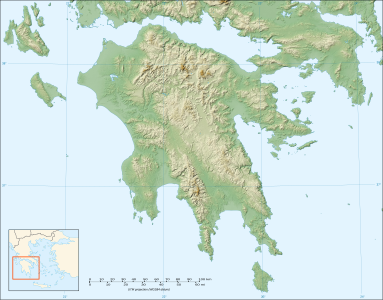
English: Blank map of the relief of Peloponnese, Greece.
Français : Carte vierge du relief du Péloponnèse, Grèce. UTM projection; WGS84 datum; shaded relief (composite image of N-W, W and N lightning positions) |
||
| Datum | |||
| Quälle |
Own work ;
|
||
| Urheber | Eric Gaba (Sting - fr:Sting) | ||
| Gnähmigung (Wyternutzig vu däre Datei) |
|
||
| Anderi Versione |
|

Lizänzierig
Ich haa s Urheberrächt an däm Wärch un vereffetlig s dodermit unter däne Lizänze:

|
Des Dokumänt derf kopiert, verbreitet un/oder bearbeitet wäre unter dr Bedingige vu dr GNU-Lizänz fir freji Dokumäntation, Version 1.2 oder ere spetere Version, vereffetligt dur Free Software Foundation. S het keini uuveränderlige Abschnitt, kei vordere Umschlagstext un kei hindere Umschlagstext. E Kopii vu dr Lizänz isch verfiegbar im Abschnitt GNU-Lizänz fir freji Dokumäntation. |
Die Datei isch lizänziert unter dr Creative-Commons-Lizänze Namensnännig – Wytergab unter glyche Bedingige 3.0 nit portiert, 2.5 generisch, 2.0 generisch un 1.0 generisch.
- Du derfsch:
- des Wärch an anderi wytergee – des Wärch kopiere, verbreite un ibertrage
- des Wärch verändere – des Wärch aapasse
- Unter däne Bedingige:
- Namenännig – Du muesch aagmässeni Aagabe zum Urheber un dr Rächt mache, e Link zue dr Lizänz zuefiege un aagee, eb Änderige gmacht wore sin. Die Aagabe chenne in ere aagmässene Art gmacht wäre, aber nit eso, ass dr Yydruck entstoht, ass dr Lizänzgeber Dii oder Dyy Gebruch vum Wärch unterstitze un guetheiße.
- Wytergab unter glyche Bedingige – Wänn du des Wärch veränderesch, umwandlesch oder druf ufböusch, no derfsch s Ergebnis nume unter dr glyche oder ere kumpatible Lizänz wie s Orginal vereffetlige.
Du chasch sälber e Lizänz uuswehle.
Dateiversione
Klick uf e Zytpunkt zu aazeige, wie s dert usgsäh het.
| Version vom | Vorschaubild | Mäß | Benutzer | Kommentar | |
|---|---|---|---|---|---|
| aktuell | 22:32, 18. Okt. 2007 | | 2.611 × 2.044 (1,97 MB) | Sting | {{Information |Description=Blank map of the relief of Peloponnese, Greece |Source=Own work ;<br/>Topographic background map : [http://www2.jpl.nasa.gov/srtm NASA Shuttle Radar Topography Mission] (SRTM3 v.2) (public domain) edited with |
Verwändig vu dr Datei
Kei Artikel bruucht die Datei.
Wältwyti Dateinutzig
Die andere Wikis bruche die Datei:
- Gebruch uf ar.wikipedia.org
- Gebruch uf ba.wikipedia.org
- Gebruch uf bs.wikipedia.org
- Gebruch uf ceb.wikipedia.org
- Gebruch uf de.wikipedia.org
- Gebruch uf el.wikipedia.org
- Gebruch uf en.wikipedia.org
- Gebruch uf en.wikiversity.org
- Gebruch uf eo.wikipedia.org
- Gebruch uf es.wikipedia.org
- Ménalo (monte)
- Canal de Corinto
- Monte Taigeto
- Monte Erimanto
- Plantilla:Mapa de localización de Peloponeso
- Río Peneo (Peloponeso)
- Estínfalo (Arcadia)
- Cueva de Néstor
- Vouraikos
- Aroania
- Cueva de los Lagos
- Skollis
- Monte Afrodisio
- Necrópolis micénica de Aidonia
- Korakou (Corinto)
- Bosque de Folói
- Cueva de Alepotrypa
Wältwyti Verwändig vu däre Datei aaluege.