
Datei:Map of the Arab-Israeli conflict-blank.svg

Gröössi vor PNG-Vorschou vor SVG-Datei: 800 × 426 Pixel. Wyteri Ufflösige: 320 × 170 Pixel | 640 × 341 Pixel | 1.024 × 545 Pixel | 1.280 × 682 Pixel | 2.560 × 1.363 Pixel | 920 × 490 Pixel.
Originaldatei (SVG-Datei, Basisgrößi: 920 × 490 Pixel, Dateigrößi: 450 KB)
| Die Datei un d Informatione derzue were us em zäntrale Mediearchiv Wikimedia Commons (Allmänd) iibunde. | Zur Bschriibigssite uff de Allmänd |
Bschryybig
| Bschryybig |
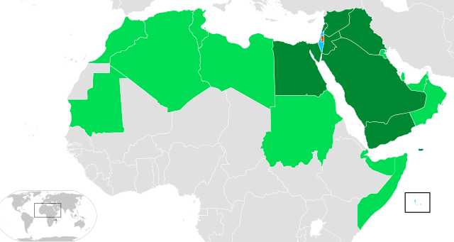
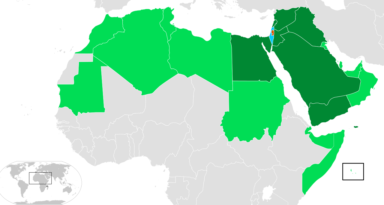
Français : Carte d'Israël et des membres de la Ligue arabe (les Comores sont visibles en bas à droite)
|
| Datum | (UTC) |
| Quälle | Eigeni Arbet |
| Urheber | ҉ Cerveaugenie |
Israel
Gaza and the West Bank (State of Palestine)
Arab League countries
Arab League countries that have been in war with Israel
Lizänzierig
Ich haa s Urheberrächt an däm Wärch un vereffetlig s dodermit unter däne Lizänze:

|
Des Dokumänt derf kopiert, verbreitet un/oder bearbeitet wäre unter dr Bedingige vu dr GNU-Lizänz fir freji Dokumäntation, Version 1.2 oder ere spetere Version, vereffetligt dur Free Software Foundation. S het keini uuveränderlige Abschnitt, kei vordere Umschlagstext un kei hindere Umschlagstext. E Kopii vu dr Lizänz isch verfiegbar im Abschnitt GNU-Lizänz fir freji Dokumäntation. |
Die Datei isch lizänziert unter dr Creative-Commons-Lizänze Namensnännig – Wytergab unter glyche Bedingige 3.0 nit portiert, 2.5 generisch, 2.0 generisch un 1.0 generisch.
- Du derfsch:
- des Wärch an anderi wytergee – des Wärch kopiere, verbreite un ibertrage
- des Wärch verändere – des Wärch aapasse
- Unter däne Bedingige:
- Namenännig – Du muesch aagmässeni Aagabe zum Urheber un dr Rächt mache, e Link zue dr Lizänz zuefiege un aagee, eb Änderige gmacht wore sin. Die Aagabe chenne in ere aagmässene Art gmacht wäre, aber nit eso, ass dr Yydruck entstoht, ass dr Lizänzgeber Dii oder Dyy Gebruch vum Wärch unterstitze un guetheiße.
- Wytergab unter glyche Bedingige – Wänn du des Wärch veränderesch, umwandlesch oder druf ufböusch, no derfsch s Ergebnis nume unter dr glyche oder ere kumpatible Lizänz wie s Orginal vereffetlige.
Du chasch sälber e Lizänz uuswehle.
Dateiversione
Klick uf e Zytpunkt zu aazeige, wie s dert usgsäh het.
| Version vom | Vorschaubild | Mäß | Benutzer | Kommentar | |
|---|---|---|---|---|---|
| aktuell | 13:00, 21. Aug. 2013 | | 920 × 490 (450 KB) | Hytar | Redone from scratch, exclude South Sudan and Western Sahara from Arab League |
| 14:18, 8. Jul. 2008 |  | 940 × 477 (1,87 MB) | Cerveaugenie | +mauritanie | |
| 12:22, 8. Jul. 2008 |  | 940 × 477 (1,87 MB) | Cerveaugenie | colours | |
| 19:28, 7. Jul. 2008 |  | 940 × 477 (1,87 MB) | Cerveaugenie | {{Information |Description={{en|1=Map of Israel and members of the Arab League (Comoros is shown in bottom right).}} {{fr|1=Carte d'Israël et des membres de la fr:Ligue Arabe (les Comores son visibles en bas � |
Verwändig vu dr Datei
Di folgende Sytene händ en Link zu dem Bildli:
Wältwyti Dateinutzig
Die andere Wikis bruche die Datei:
- Gebruch uf de.wikipedia.org
- Gebruch uf en.wikipedia.org
- Gebruch uf es.wikipedia.org
- Gebruch uf gl.wikipedia.org
- Gebruch uf gn.wikipedia.org
- Gebruch uf ka.wikipedia.org
- Gebruch uf www.wikidata.org
- Gebruch uf zh.wikipedia.org