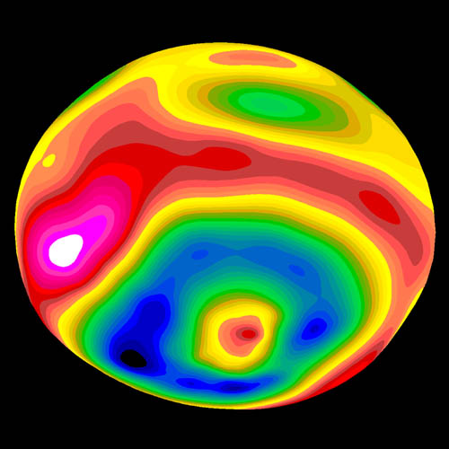
Datei:Vesta-Elevation.jpg
Erscheinungsbild
Vesta-Elevation.jpg (500 × 500 Pixel, Dateigrößi: 43 KB, MIME-Typ: image/jpeg)
Dateiversione
Klick uf e Zytpunkt zu aazeige, wie s dert usgsäh het.
| Version vom | Vorschaubild | Mäß | Benutzer | Kommentar | |
|---|---|---|---|---|---|
| aktuell | 08:57, 30. Jan. 2006 |  | 500 × 500 (43 KB) | Arnomane | higher resolution |
| 18:56, 24. Aug. 2005 |  | 200 × 200 (6 KB) | Vesta~commonswiki | * Description: A color-encoded elevation map of Vesta clearly shows the giant 460-kilometer diameter impact basin and "bull's-eye" central peak. The map was constructed from 78 Wide Field Planetary Camera 2 pictures. Surface topography was estimated by no |
Verwändig vu dr Datei
Di folgende Sytene händ en Link zu dem Bildli:
Wältwyti Dateinutzig
Die andere Wikis bruche die Datei:
- Gebruch uf ar.wikipedia.org
- Gebruch uf ca.wikipedia.org
- Gebruch uf cs.wikipedia.org
- Gebruch uf de.wikipedia.org
- Gebruch uf en.wikipedia.org
- Gebruch uf es.wikipedia.org
- Gebruch uf eu.wikipedia.org
- Gebruch uf fa.wikipedia.org
- Gebruch uf fi.wikipedia.org
- Gebruch uf fr.wikipedia.org
- Gebruch uf ko.wikipedia.org
- Gebruch uf lb.wikipedia.org
- Gebruch uf mk.wikipedia.org
- Gebruch uf oc.wikipedia.org
- Gebruch uf pt.wikipedia.org
- Gebruch uf ro.wikipedia.org
- Gebruch uf simple.wikipedia.org
- Gebruch uf sk.wikipedia.org
- Gebruch uf sv.wikipedia.org
- Gebruch uf uk.wikipedia.org
- Gebruch uf www.wikidata.org
- Gebruch uf zh.wikipedia.org


