Datei:LocationWesternAfrica.png
Erscheinungsbild
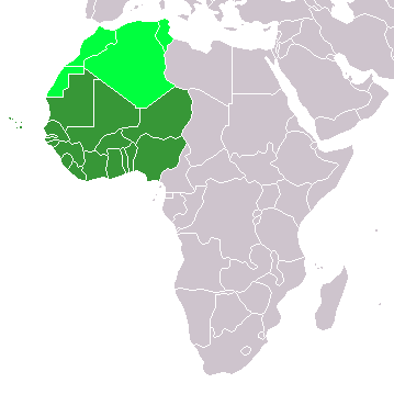
LocationWesternAfrica.png (359 × 359 Pixel, Dateigrößi: 7 KB, MIME-Typ: image/png)
Dateiversione
Klick uf e Zytpunkt zu aazeige, wie s dert usgsäh het.
| Version vom | Vorschaubild | Mäß | Benutzer | Kommentar | |
|---|---|---|---|---|---|
| aktuell | 14:17, 11. Nov. 2022 |  | 359 × 359 (7 KB) | ColorfulSmoke | . |
| 12:56, 11. Nov. 2022 |  | 360 × 359 (7 KB) | ColorfulSmoke | ||
| 17:47, 17. Mär. 2018 |  | 360 × 392 (10 KB) | Maphobbyist | Upload | |
| 21:54, 31. Mär. 2016 |  | 360 × 392 (13 KB) | Fry1989 | Reverted to version as of 21:24, 9 July 2011 (UTC) | |
| 00:24, 16. Mär. 2016 |  | 360 × 392 (10 KB) | Hpyounes | new colors | |
| 22:24, 9. Jul. 2011 |  | 360 × 392 (13 KB) | Maphobbyist | South Sudan has become independent on July 9, 2011. Sudan and South Sudan are shown with the new international border between them. | |
| 09:09, 11. Dez. 2007 |  | 360 × 392 (14 KB) | Hoshie | added Cabinda (Angola) and Montenegro. | |
| 11:55, 5. Feb. 2006 |  | 360 × 392 (8 KB) | E Pluribus Anthony~commonswiki | Map: Western Africa, including Maghreb (location) | |
| 20:52, 4. Feb. 2006 |  | 360 × 392 (9 KB) | E Pluribus Anthony~commonswiki | Map: Western Africa, including Maghreb (location) |
Verwändig vu dr Datei
Di folgende Sytene händ en Link zu dem Bildli:
Wältwyti Dateinutzig
Die andere Wikis bruche die Datei:
- Gebruch uf ab.wikipedia.org
- Gebruch uf ace.wikipedia.org
- Gebruch uf af.wikipedia.org
- Gebruch uf am.wikipedia.org
- Gebruch uf ar.wikipedia.org
- ليبيا
- جيبوتي
- موريتانيا
- تونس
- السودان
- الصحراء الغربية
- أنغولا
- أوغندا
- إسبانيا
- تشاد
- النيجر
- مالي
- السنغال
- غامبيا
- غينيا بيساو
- غينيا
- سيراليون
- ليبيريا
- غانا
- توغو
- بنين
- بوركينا فاسو
- الصومال
- كينيا
- تنزانيا
- الغابون
- زامبيا
- موزمبيق
- زيمبابوي
- البرتغال
- الكاميرون
- جمهورية الكونغو الديمقراطية
- بوتسوانا
- جنوب إفريقيا
- جمهورية إفريقيا الوسطى
- جمهورية الكونغو
- سيشل
- ناميبيا
- مدغشقر
Wältwyti Verwändig vu däre Datei aaluege.


