
Datei:Tycho Crater Panorama.jpg
Tycho_Crater_Panorama.jpg (625 × 480 Pixel, Dateigrößi: 97 KB, MIME-Typ: image/jpeg)
| Die Datei un d Informatione derzue were us em zäntrale Mediearchiv Wikimedia Commons (Allmänd) iibunde. | Zur Bschriibigssite uff de Allmänd |
Bschryybig
| Bschryybig |
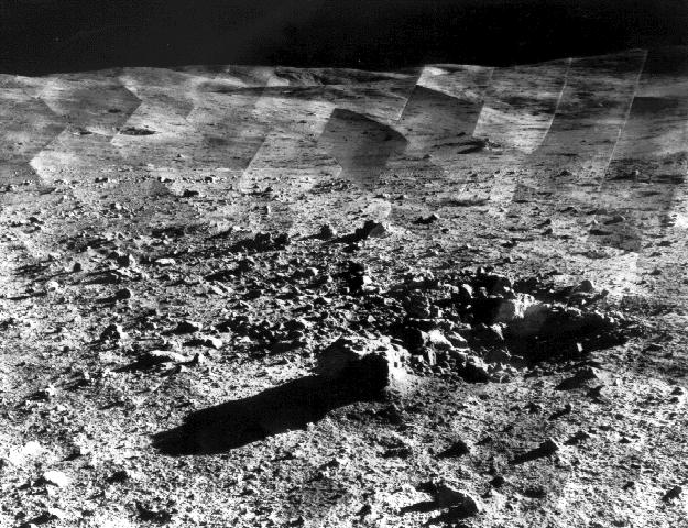
Original-Bildunterschrift: „ Photomosaic of lunar panorama near the Tycho crater taken by Surveyor 7. The hills on the center horizon are about eight miles away from the spacecraft. “Since the landing site survey for the Apollo missions had been successfully completed by the previous Surveyors, the landing site for Surveyor 7 was selected more for its scientific interest. Surveyor 7, in addition to taking thousands of images and gathering a wide variety of surface data, performed star surveys, took pictures of Earth, and tested laser-pointing techniques by detecting laser beams from Earth. |
| Datum | between 10-Jan-1968 and 26-Jan-1968 |
| Quälle | http://photojournal.jpl.nasa.gov/catalog/PIA02977 |
| Urheber | Courtesy NASA/JPL-Caltech |
| Gnähmigung (Wyternutzig vu däre Datei) |
may be used for any purpose without prior permission |
| Position auf dem Mond | Dieses und weitere Bilder auf Google Maps |
|---|
Lizänzierig
| Diese Datei ist gemeinfrei (public domain), da sie von der NASA erstellt worden ist. Die NASA-Urheberrechtsrichtlinie besagt, dass „NASA-Material nicht durch Urheberrecht geschützt ist, wenn es nicht anders angegeben ist“. (NASA-Urheberrechtsrichtlinie-Seite oder JPL Image Use Policy). | ||
 |
Warnung:
|
Dateiversione
Klick uf e Zytpunkt zu aazeige, wie s dert usgsäh het.
| Version vom | Vorschaubild | Mäß | Benutzer | Kommentar | |
|---|---|---|---|---|---|
| aktuell | 20:07, 14. Jan. 2006 | | 625 × 480 (97 KB) | W-j-s | == Summary == Original Caption Released with Image taken from [http://photojournal.jpl.nasa.gov/catalog/PIA02977 jpl site]: Photomosaic of lunar panorama near the Tycho crater taken by Surveyor 7. The hills on the center horizon are about |
Verwändig vu dr Datei
Di folgende Sytene händ en Link zu dem Bildli:
Wältwyti Dateinutzig
Die andere Wikis bruche die Datei:
- Gebruch uf ar.wikipedia.org
- Gebruch uf ca.wikipedia.org
- Gebruch uf cs.wikipedia.org
- Gebruch uf da.wikipedia.org
- Gebruch uf el.wikipedia.org
- Gebruch uf en.wikipedia.org
- Gebruch uf et.wikipedia.org
- Gebruch uf fr.wikipedia.org
- Gebruch uf hu.wikipedia.org
- Gebruch uf id.wikipedia.org
- Gebruch uf io.wikipedia.org
- Gebruch uf it.wikipedia.org
- Gebruch uf ja.wikipedia.org
- Gebruch uf ms.wikipedia.org
- Gebruch uf nl.wikipedia.org
- Gebruch uf nn.wikipedia.org
- Gebruch uf oc.wikipedia.org
- Gebruch uf pl.wikipedia.org
- Gebruch uf ru.wikipedia.org
- Gebruch uf sr.wikipedia.org
- Gebruch uf sv.wikipedia.org
- Gebruch uf ta.wikipedia.org
- Gebruch uf uk.wikipedia.org
- Gebruch uf vi.wikipedia.org
- Gebruch uf zh.wikipedia.org