
Datei:SuluRangeNASA.jpg
Kei höcheri Uflösig verfüegbar.
SuluRangeNASA.jpg (640 × 422 Pixel, Dateigrößi: 57 KB, MIME-Typ: image/jpeg)
| Die Datei un d Informatione derzue were us em zäntrale Mediearchiv Wikimedia Commons (Allmänd) iibunde. | Zur Bschriibigssite uff de Allmänd |
Bschryybig
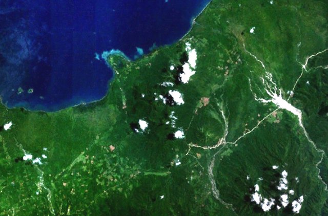
| Bschryybig | Forested volcanoes of the Sulu Range occupy the center of this NASA Landsat image (with north to the top) of west-central New Britain. This group of partially overlapping small stratovolcanoes and lava domes off Bangula Bay reaches heights of about 600 m. Mount Karai, also known as Mount Ruckenberg, lies on the NE side of the geochemically diverse, basaltic-to-rhyolitic complex. Kaiamu maar forms the peninsula extending about 1 km into Bangula Bay at the NW side of the Sulu Range. | |||||
| Datum | Nit bekannt Datum | |||||
| Quälle | http://www.volcano.si.edu/world/volcano.cfm?vnum=0502-09= | |||||
| Urheber | NASA Landsat7 image (worldwind.arc.nasa.gov) | |||||
| Gnähmigung (Wyternutzig vu däre Datei) |
|
|||||
| Ort | New Britain, Papua New Guinea |

Dateiversione
Klick uf e Zytpunkt zu aazeige, wie s dert usgsäh het.
| Version vom | Vorschaubild | Mäß | Benutzer | Kommentar | |
|---|---|---|---|---|---|
| aktuell | 06:58, 22. Apr. 2007 | | 640 × 422 (57 KB) | Seattle Skier | == Summary == {{Information |Description= Forested volcanoes of the Sulu Range occupy the center of this NASA Landsat image of west-central New Britain (north to the top). Papua New Guinea |Source= http://www.volcano.si.edu/world/volca |
Verwändig vu dr Datei
Di folgende Sytene händ en Link zu dem Bildli:
Wältwyti Dateinutzig
Die andere Wikis bruche die Datei:
- Gebruch uf arz.wikipedia.org
- Gebruch uf ceb.wikipedia.org
- Gebruch uf de.wikipedia.org
- Gebruch uf en.wikipedia.org
- Gebruch uf www.wikidata.org