
Datei:South America southern tip pol.png

Greßi vu däre Vorschau: 800 × 494 Pixel. Wyteri Ufflösige: 320 × 198 Pixel | 640 × 395 Pixel | 1.024 × 632 Pixel | 1.280 × 790 Pixel | 2.560 × 1.581 Pixel | 3.859 × 2.383 Pixel.
Originaldatei (3.859 × 2.383 Pixel, Dateigrößi: 596 KB, MIME-Typ: image/png)
| Die Datei un d Informatione derzue were us em zäntrale Mediearchiv Wikimedia Commons (Allmänd) iibunde. | Zur Bschriibigssite uff de Allmänd |
Bschryybig
| Bschryybig |
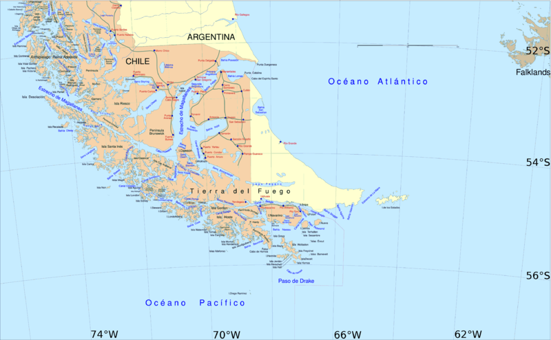
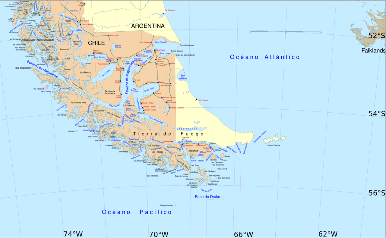
English: Political map of southern Chile and Argentina, from Straits of Magellan to Cape Horn.
Español: Mapa político del sur de Chile y la Argentina, entre el estrecho de Magallanes y el cabo de Hornos. |
||||
| Datum | |||||
| Quälle | File:Sur2.gif | ||||
| Urheber | User:Createaccount | ||||
| Gnähmigung (Wyternutzig vu däre Datei) |
|
||||
| Anderi Versione | Abgleiteti Wärk vo dere Datei: Metula.svg |
Lizänzierig

|
Des Dokumänt derf kopiert, verbreitet un/oder bearbeitet wäre unter dr Bedingige vu dr GNU-Lizänz fir freji Dokumäntation, Version 1.2 oder ere spetere Version, vereffetligt dur Free Software Foundation. S het keini uuveränderlige Abschnitt, kei vordere Umschlagstext un kei hindere Umschlagstext. E Kopii vu dr Lizänz isch verfiegbar im Abschnitt GNU-Lizänz fir freji Dokumäntation. |
| Die Datei isch lizänziert unter dr Creative-Commons-Lizenz Namensnännig – Wytergab unter glyche Bedingige 3.0 nit portiert. | ||
| ||
| Die Lizänzmarkierig isch wäg em GFDL-Lizänzupdate zuegfiegt wore. |
Dateiversione
Klick uf e Zytpunkt zu aazeige, wie s dert usgsäh het.
| Version vom | Vorschaubild | Mäß | Benutzer | Kommentar | |
|---|---|---|---|---|---|
| aktuell | 16:06, 30. Apr. 2016 | | 3.859 × 2.383 (596 KB) | Hohum | Cartographic colours |
| 13:09, 3. Apr. 2013 |  | 3.859 × 2.383 (597 KB) | Keysanger | Margin right and top cropped | |
| 12:47, 3. Apr. 2013 |  | 3.859 × 2.383 (597 KB) | Keysanger | "Estrecho Nelson" added Bigger Latitude and Longitude within the image empty margin cropped | |
| 21:30, 3. Mai 2009 |  | 3.894 × 2.441 (639 KB) | Pitichinaccio | different colour | |
| 21:29, 3. Mai 2009 |  | 3.894 × 2.441 (639 KB) | Pitichinaccio | {{Information |Description={{en|1=political map of southern Chile/Argentina: From Straits of Magellan to Cape Horn}} |Source=File:Sur2.gif |Author=User:Createaccount |Date=2008 |Permission={{GFDL-GMT}}} |other_versions=File:Sur2.gif }} <!-- |
Verwändig vu dr Datei
Di folgende Sytene händ en Link zu dem Bildli:
Wältwyti Dateinutzig
Die andere Wikis bruche die Datei:
- Gebruch uf af.wikipedia.org
- Gebruch uf ar.wikipedia.org
- Gebruch uf ast.wikipedia.org
- Gebruch uf br.wikipedia.org
- Gebruch uf ca.wikipedia.org
- Gebruch uf de.wikipedia.org
- Gebruch uf de.wiktionary.org
- Gebruch uf el.wikipedia.org
- Gebruch uf en.wikipedia.org
- Cape Froward
- Porvenir, Chile
- Santa Inés Island
- Puerto Toro
- False Cape Horn
- Puerto del Hambre
- Maritime history of California
- Brunswick Peninsula
- Almirantazgo Fjord
- Fjord of the Mountains
- Primera Angostura
- Aracena Island
- Punta Dúngeness
- Muñoz Gamero Peninsula
- Seno Otway
- Mitre Peninsula
- Marlborough (1876 ship)
- Camerón
Wältwyti Verwändig vu däre Datei aaluege.