
Datei:RegioniIrredenteItalia.jpg
Greßi vu däre Vorschau: 460 × 600 Pixel. Wyteri Ufflösige: 184 × 240 Pixel | 632 × 824 Pixel.
Originaldatei (632 × 824 Pixel, Dateigrößi: 247 KB, MIME-Typ: image/jpeg)
| Die Datei un d Informatione derzue were us em zäntrale Mediearchiv Wikimedia Commons (Allmänd) iibunde. | Zur Bschriibigssite uff de Allmänd |
Bschryybig
| Bschryybig |
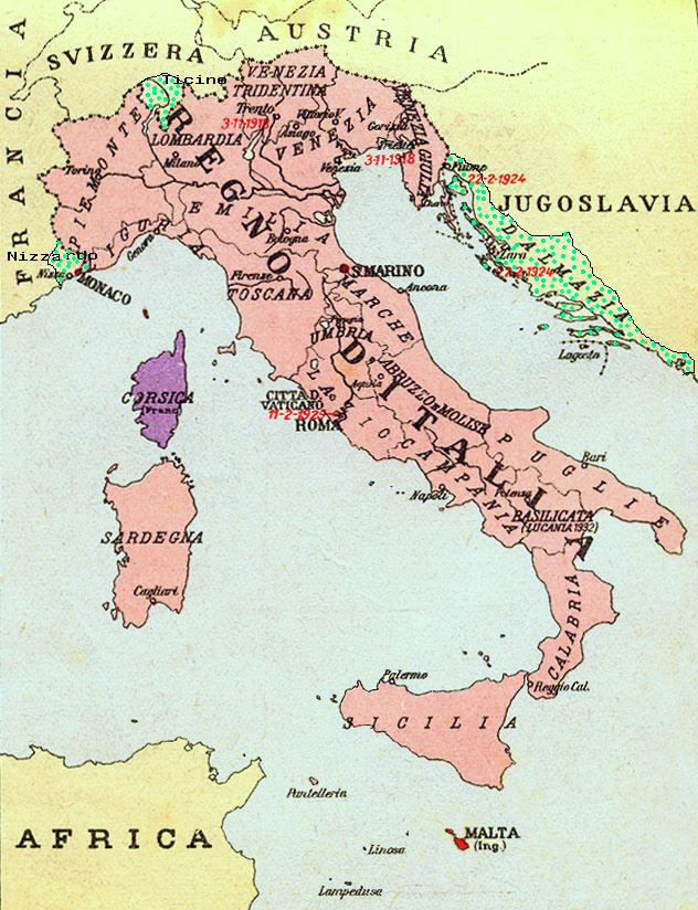
Map of Kingdom of Italy (1919) showing the areas claimed by Irredentism: in red Malta, in purple Corsica, in yellow with green points Dalmatia, Ticino and Nizzardo. I have used as a basic map an old map from an Italian geography and history school book of 1935 "Scuole Medie Inferiori", and I have written and painted on it. Cropped caption: L’Italia dopo la Guerra 1915-1918 |
| Datum | |
| Quälle | Eigeni Arbet |
| Urheber | Brunodambrosio |
| Anderi Versione | File:Nesvobodni rajoni Italija.png |
Lizänzierig
| Ich, dr Urheberrächtsinhaber vu däm Wärch, tue s as gmeinfrej vereffentlige . Des giltet wältwyt. In mänke Staate chennt des rächtli nit megli syy. Wänn des imfall eso isch: Ich gib e jedem s bedingiglos Rächt, des Wärch jedwädere Zwäck z nutze, ußer s git gesetzlig erforderligi Bedingige. |
Dateiversione
Klick uf e Zytpunkt zu aazeige, wie s dert usgsäh het.
| Version vom | Vorschaubild | Mäß | Benutzer | Kommentar | |
|---|---|---|---|---|---|
| aktuell | 23:34, 17. Aug. 2023 | | 632 × 824 (247 KB) | 0m9Ep | Color |
| 12:14, 23. Dez. 2017 |  | 632 × 824 (262 KB) | Julieta39 | Blù delle mare | |
| 00:58, 8. Jun. 2012 |  | 632 × 824 (119 KB) | Ras67 | losslessly cropped with Jpegcrop | |
| 00:01, 17. Apr. 2008 |  | 669 × 903 (144 KB) | Brunodambrosio | {{Information |Description=Map of Kingdom of Italy (1919) showing the areas claimed by Irredentism:in red Malta, in purple Corsica, in yellow with green points Dalmatia, Ticino and Nizzardo. I have used as a basic map an old map from an italian geography |
Verwändig vu dr Datei
Di folgende Sytene händ en Link zu dem Bildli:
Wältwyti Dateinutzig
Die andere Wikis bruche die Datei:
- Gebruch uf ar.wikipedia.org
- Gebruch uf ast.wikipedia.org
- Gebruch uf az.wikipedia.org
- Gebruch uf be-tarask.wikipedia.org
- Gebruch uf be.wikipedia.org
- Gebruch uf ca.wikipedia.org
- Gebruch uf cs.wikipedia.org
- Gebruch uf de.wikipedia.org
- Gebruch uf de.wiktionary.org
- Gebruch uf en.wikipedia.org
- Foreign relations of Italy
- Irredentism
- Italian irredentism
- History of the Kingdom of Italy (1861–1946)
- List of irredentist claims or disputes
- Italian fascism
- Kingdom of Italy
- History of Corsica
- Italian irredentism in Corsica
- Benito Mussolini
- Italian irredentism in Malta
- Italian irredentism in Switzerland
- User:Brothernight/sandbox
- Gebruch uf eo.wikipedia.org
- Gebruch uf es.wikipedia.org
- Gebruch uf fa.wikipedia.org
- Gebruch uf fr.wikipedia.org
- Gebruch uf he.wikipedia.org
- Gebruch uf hr.wikipedia.org
- Gebruch uf hu.wikipedia.org
- Gebruch uf hy.wikipedia.org
- Gebruch uf id.wikipedia.org
Wältwyti Verwändig vu däre Datei aaluege.