Datei:Ocean drainage.png
Seiteninhalte werden in anderen Sprachen nicht unterstützt.
Us der alemannische Wikipedia, der freie Dialäkt-Enzyklopedy

Originaldatei(1.256 × 656 Pixel, Dateigrößi: 75 KB, MIME-Typ: image/png)

Die Datei un d Informatione derzue were us em zäntrale Mediearchiv Wikimedia Commons (Allmänd) iibunde. Zur Bschriibigssite uff de Allmänd Zur Bschriibigssite uff de Allmänd

Bschryybig

Dieses Bild des Typs Map sollte als Vektorgrafik im SVG-Format neu erstellt werden. Vektorformate haben zahlreiche Vorteile; weitere Information unter Commons:Media for cleanup. Wenn dir eine SVG-Version dieses Bildes vorliegt, so lade diese bitte hoch. Nach dem Hochladen der Datei ist diese Vorlage auf der aktuellen Bildbeschreibungsseite durch die Vorlage {{Vector version available}}, oder kürzer {{Vva}}, zu ersetzen. Es ist empfohlen die neue SVG-Datei „Ocean drainage.svg“ zu nennen – dann benötigt die Vorlage vector version available (bzw. vva) keinen Parameter.
Bschryybig
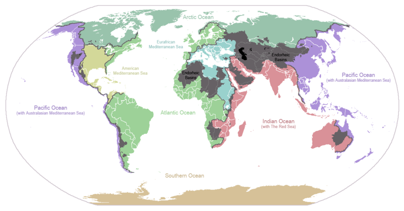
English: I made this map and hereby release it into the public domain. It shows the drainage basins for the major oceans and seas; grey areas are endorheic basins that do not drain to the ocean. Data is from the USGS Hydro1k project; information for Saskatchewan corrected by information from the Commission for Environmental Cooperation -- Citynoise
Description in large font size is used for oceans, in smaller font size is used for mediterranean seas. Only these mediterranean seas are listed which correspond to the definition of german Geographer Ernst Neef: A mediterranean sea is a sea between two Continents. Also found here: de:Mittelmeer --W like wiki (talk) 00:55, 12 March 2011 (UTC)
Français : Carte du monde des bassins versants. Les zones de couleur anthracite représentent les bassins endoréiques, qui ne sont reliés à aucun océan.
Čeština: Úmoří světových oceánů, popř. významných moří či zálivů. Legenda úmoří: fialová - Tichý oceán, růžová - Indický oceán, zelená - Atlantický oceán, azurová - Severní ledový oceán, béžová - Jižní oceán, modrá - Mexický záliv, světle modrá - Středozemní moře, šedá - oblast neústící ve světovém oceánu
Datum 24. Jänner 2007 (Original-Hochladedatum)
Quälle Übertragen aus en.wikipedia nach Commons.
Urheber Citynoise in der Wikipedia auf Änglisch
Anderi Versione File:Major endorheic basins.png

Lizänzierig

Public domain Des Wärch isch vu syym Urheber Citynoise in der Wikipedia auf Änglisch as gmeinfrej vereffentligt wore. Des giltet wältwyt.
In mänke Staate chennt des rächtli nit megli syy. Wänn des imfall eso isch:
Citynoise git e jedem s bedingigslos Rächt, des Wärch fir jedwädere Zwäck z nutze, ußer s git gesetzlig erforderligi Bedingige.

Orginal Logbuech vu uffegladene Datei

Die ursprüngliche Dateibeschreibungsseite war hier. Alle folgenden Benutzernamen beziehen sich auf en.wikipedia.
  • 2007-05-20 17:59 Bolonium 1256×656×8 (50194 bytes) I made this map and hereby release it into the public domain. It shows the drainage basins for the major oceans and seas; grey areas are endorheic basins that do not drain to the ocean. -- [[User:Citynoise|Citynoise]] == Licensing == {{self
  • 2007-01-24 07:21 Citynoise 1256×656×8 (63359 bytes) I made this map and hereby release it into the public domain. It shows the drainage basins for the major oceans and seas; grey areas are endorheic basins that do not drain to the ocean.
  • 2007-01-24 06:09 Citynoise 1256×656×8 (57358 bytes) I made this map and hereby release it into the public domain. It shows the drainage basins for the major oceans and seas; grey areas are endorheic basins that do not drain to the ocean.
  • 2007-01-24 05:10 Citynoise 1256×656×8 (56360 bytes) I made this map and hereby release it into the public domain. It shows the drainage basins for the major oceans and seas; grey areas are endorheic basins that do not drain to the ocean.
  • 2007-01-24 04:55 Citynoise 1256×656×8 (56373 bytes) I made this map and hereby release it into the public domain. It shows the drainage basins for the major oceans and seas; grey areas are endorheic basins that do not drain to the ocean.

Kurzbeschreibungen

Ergänze eine einzeilige Erklärung, was diese Datei darstellt.
Drainage basins of the world, colored by ocean outlet. Endorheic basins not draining to an ocean are colored dark gray. Continental divides are indicated by dark lines.

In dieser Datei abgebildete Objekte

Motiv

Dateiversione

Klick uf e Zytpunkt zu aazeige, wie s dert usgsäh het.

Version vomVorschaubildMäßBenutzerKommentar
aktuell01:25, 7. Okt. 2015Vorschaubild fir Version vum 01:25, 7. Okt. 20151.256 × 656 (75 KB)AcidSnowFixed Somalia.
02:39, 12. Mär. 2011Vorschaubild fir Version vum 02:39, 12. Mär. 20111.256 × 656 (76 KB)W like wikiInsert Description. Big font size is used for oceans, smaller font size is used for mediterranean seas.
13:13, 30. Jun. 2009Vorschaubild fir Version vum 13:13, 30. Jun. 20091.256 × 656 (40 KB)U7vGuntransparentize background,improve some details.
22:45, 26. Jul. 2008Vorschaubild fir Version vum 22:45, 26. Jul. 20081.256 × 656 (62 KB)Citynoise{{Information |Description=added endorheic basins in Saskatchewan. |Source=my own work |Date=July 2008 |Author=Citynoise |Permission=all rights released |other_versions= }}
21:46, 27. Nov. 2007Vorschaubild fir Version vum 21:46, 27. Nov. 20071.256 × 656 (49 KB)File Upload Bot (Magnus Manske) {{BotMoveToCommons|en.wikipedia}} {{Information |Description={{en|I made this map and hereby release it into the public domain. It shows the drainage basins for the major oceans and seas; grey areas are en:endorheic basins that do not drain to the

Di folgende Sytene händ en Link zu dem Bildli:

Wältwyti Dateinutzig

Die andere Wikis bruche die Datei:

Wältwyti Verwändig vu däre Datei aaluege.

Metadate