
Datei:Map of Oregon NA.png

Greßi vu däre Vorschau: 800 × 541 Pixel. Wyteri Ufflösige: 320 × 217 Pixel | 640 × 433 Pixel | 1.024 × 693 Pixel | 1.280 × 866 Pixel | 1.967 × 1.331 Pixel.
Originaldatei (1.967 × 1.331 Pixel, Dateigrößi: 2,15 MB, MIME-Typ: image/png)
| Die Datei un d Informatione derzue were us em zäntrale Mediearchiv Wikimedia Commons (Allmänd) iibunde. | Zur Bschriibigssite uff de Allmänd |
Bschryybig
| Bschryybig |
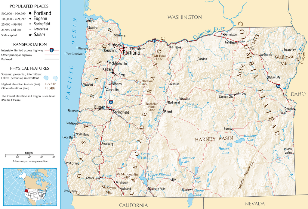
English: Topographic map of the geography of Oregon — with major rivers shown.
|
| Quälle | National Atlas |
| Urheber | Autor/-in unbekannt |
Lizänzierig
Diese Karte stammt aus einer Ausgabe des National Atlas of the United States. Wie fast alle Arbeiten der Regierung der Vereinigten Staaten sind Arbeiten des National Atlas in den USA gemeinfrei.
Online-Zugang: NationalAtlas.gov | Gedruckte Ausgabe von 1970: Library of Congress, Perry-Castañeda Library
|
Dateiversione
Klick uf e Zytpunkt zu aazeige, wie s dert usgsäh het.
| Version vom | Vorschaubild | Mäß | Benutzer | Kommentar | |
|---|---|---|---|---|---|
| aktuell | 07:46, 16. Okt. 2007 | | 1.967 × 1.331 (2,15 MB) | Peteforsyth | removed extraneous text and logo from public domain image |
| 10:13, 15. Aug. 2006 |  | 2.122 × 1.640 (2,75 MB) | Huebi~commonswiki | {{Information| |Description=Map of Oregon |Source=[http://www.nationalatlas.gov National Atlas] }} Category:Maps of the United States Category:Maps of Oregon {{PD-USGov-Atlas}} |
Verwändig vu dr Datei
Di folgende Sytene händ en Link zu dem Bildli:
Wältwyti Dateinutzig
Die andere Wikis bruche die Datei:
- Gebruch uf ar.wikipedia.org
- Gebruch uf de.wikipedia.org
- Gebruch uf en.wikipedia.org
- Gebruch uf eo.wikipedia.org
- Gebruch uf fi.wikipedia.org
- Gebruch uf fr.wikipedia.org
- Gebruch uf hr.wiktionary.org
- Gebruch uf hsb.wikipedia.org
- Gebruch uf hu.wikipedia.org
- Gebruch uf incubator.wikimedia.org
- Gebruch uf is.wikipedia.org
- Gebruch uf it.wikipedia.org
- Gebruch uf ja.wikipedia.org
- Gebruch uf kk.wikipedia.org
- Gebruch uf lt.wikipedia.org
- Gebruch uf mr.wikipedia.org
- Gebruch uf nds-nl.wikipedia.org
- Gebruch uf pa.wikipedia.org
- Gebruch uf ru.wikipedia.org
- Gebruch uf sw.wikipedia.org
- Gebruch uf vi.wikipedia.org
- Gebruch uf zea.wikipedia.org