
Datei:Map of Florida NA.png

Greßi vu däre Vorschau: 776 × 600 Pixel. Wyteri Ufflösige: 311 × 240 Pixel | 621 × 480 Pixel | 994 × 768 Pixel | 1.280 × 989 Pixel | 2.122 × 1.640 Pixel.
Originaldatei (2.122 × 1.640 Pixel, Dateigrößi: 1.013 KB, MIME-Typ: image/png)
| Die Datei un d Informatione derzue were us em zäntrale Mediearchiv Wikimedia Commons (Allmänd) iibunde. | Zur Bschriibigssite uff de Allmänd |
Bschryybig
| Bschryybig | |
| Datum | |
| Quälle | |
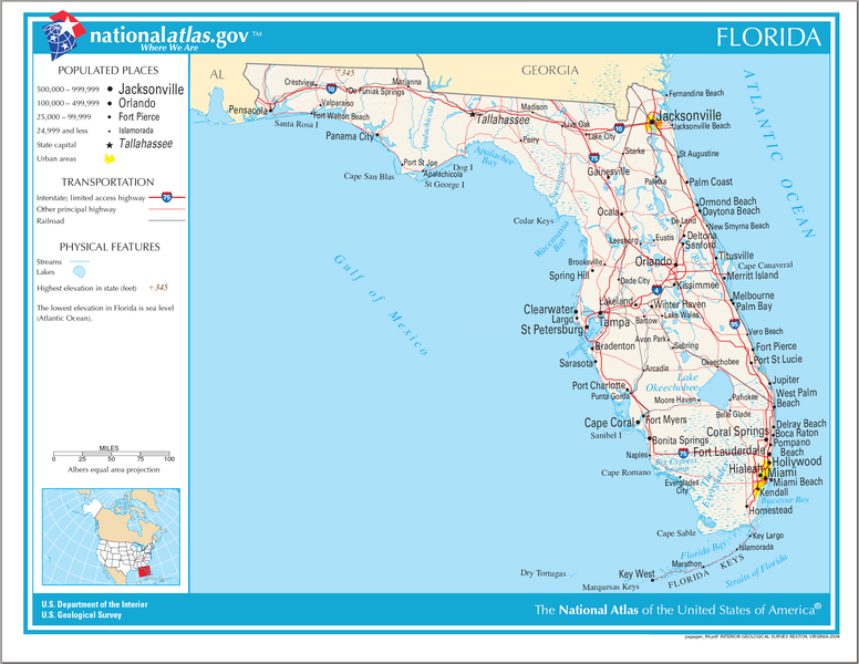
| Urheber | National Atlas of the United States |
| Gnähmigung (Wyternutzig vu däre Datei) |
Public domain |
Lizänzierig
Diese Karte stammt aus einer Ausgabe des National Atlas of the United States. Wie fast alle Arbeiten der Regierung der Vereinigten Staaten sind Arbeiten des National Atlas in den USA gemeinfrei.
Online-Zugang: NationalAtlas.gov | Gedruckte Ausgabe von 1970: Library of Congress, Perry-Castañeda Library
|
Dateiversione
Klick uf e Zytpunkt zu aazeige, wie s dert usgsäh het.
| Version vom | Vorschaubild | Mäß | Benutzer | Kommentar | |
|---|---|---|---|---|---|
| aktuell | 22:30, 14. Aug. 2006 | | 2.122 × 1.640 (1.013 KB) | Huebi~commonswiki | {{Information| |Description=Map of Florida |Source=[http://www.nationalatlas.gov National Atlas] }} Category:Maps of the United States Category:Maps of Florida {{PD-USGov-Atlas}} |
Verwändig vu dr Datei
Di folgende Sytene händ en Link zu dem Bildli:
Wältwyti Dateinutzig
Die andere Wikis bruche die Datei:
- Gebruch uf de.wikipedia.org
- Gebruch uf en.wikipedia.org
- Gebruch uf fi.wikipedia.org
- Gebruch uf fr.wikipedia.org
- Gebruch uf hsb.wikipedia.org
- Gebruch uf hu.wikipedia.org
- Gebruch uf incubator.wikimedia.org
- Gebruch uf it.wikipedia.org
- Gebruch uf pl.wikivoyage.org
- Gebruch uf sw.wikipedia.org
- Gebruch uf szl.wikipedia.org
- Gebruch uf zea.wikipedia.org