
Datei:Klimagürtel-der-erde-tropen.png

Greßi vu däre Vorschau: 800 × 400 Pixel. Wyteri Ufflösige: 320 × 160 Pixel | 640 × 320 Pixel | 1.024 × 512 Pixel | 1.280 × 640 Pixel | 3.600 × 1.800 Pixel.
Originaldatei (3.600 × 1.800 Pixel, Dateigrößi: 685 KB, MIME-Typ: image/png)
| Die Datei un d Informatione derzue were us em zäntrale Mediearchiv Wikimedia Commons (Allmänd) iibunde. | Zur Bschriibigssite uff de Allmänd |

|
Dieses Bild des Typs Meteorology sollte als Vektorgrafik im SVG-Format neu erstellt werden. Vektorformate haben zahlreiche Vorteile; weitere Information unter Commons:Media for cleanup. Wenn dir eine SVG-Version dieses Bildes vorliegt, so lade diese bitte hoch. Nach dem Hochladen der Datei ist diese Vorlage auf der aktuellen Bildbeschreibungsseite durch die Vorlage {{Vector version available}}, oder kürzer {{Vva}}, zu ersetzen. Es ist empfohlen die neue SVG-Datei „Klimagürtel-der-erde-tropen.svg“ zu nennen – dann benötigt die Vorlage vector version available (bzw. vva) keinen Parameter.
|
Bschryybig
| Bschryybig |
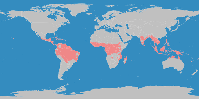
English: This map shows the Earth zones with tropical climate. Deutsch: Diese Karte stellt die tropische Klimazone der Erde dar. |
| Datum | |
| Quälle |
English: Own work on the basis of the following data: Deutsch: Selbst erstellt auf Basis dieser Geodaten:
|
| Urheber | LordToran |
| Gnähmigung (Wyternutzig vu däre Datei) |
|
| Anderi Versione |
 |
Lizänzierig
Die Datei isch lizänziert unter dr Creative-Commons-Lizenz Namensnännig – Wytergab unter glyche Bedingige 3.0 nit portiert.
- Du derfsch:
- des Wärch an anderi wytergee – des Wärch kopiere, verbreite un ibertrage
- des Wärch verändere – des Wärch aapasse
- Unter däne Bedingige:
- Namenännig – Du muesch aagmässeni Aagabe zum Urheber un dr Rächt mache, e Link zue dr Lizänz zuefiege un aagee, eb Änderige gmacht wore sin. Die Aagabe chenne in ere aagmässene Art gmacht wäre, aber nit eso, ass dr Yydruck entstoht, ass dr Lizänzgeber Dii oder Dyy Gebruch vum Wärch unterstitze un guetheiße.
- Wytergab unter glyche Bedingige – Wänn du des Wärch veränderesch, umwandlesch oder druf ufböusch, no derfsch s Ergebnis nume unter dr glyche oder ere kumpatible Lizänz wie s Orginal vereffetlige.
Dateiversione
Klick uf e Zytpunkt zu aazeige, wie s dert usgsäh het.
| Version vom | Vorschaubild | Mäß | Benutzer | Kommentar | |
|---|---|---|---|---|---|
| aktuell | 23:13, 11. Okt. 2016 | | 3.600 × 1.800 (685 KB) | Maphobbyist | The Caspian Sea was omitted. The Köppen system is based on the concept that climate types are correlated with the natural vegetation. |
| 17:26, 15. Okt. 2007 |  | 3.600 × 1.800 (585 KB) | Lortordermur | ||
| 22:49, 5. Jun. 2007 |  | 3.445 × 1.731 (628 KB) | Lortordermur | == Beschreibung == {{Information |Description=Diese Karte stellt die tropische Klimazone der Erde dar. |Source=Selbst erstellt auf Basis [http://www.copernicus.org/EGU/hess/hessd/4/439/hessd-4-439.htm dieser Karte], welche unter einer Creative-Commons-Li |
Verwändig vu dr Datei
Di folgende Sytene händ en Link zu dem Bildli:
Wältwyti Dateinutzig
Die andere Wikis bruche die Datei:
- Gebruch uf de.wikiversity.org
- Gebruch uf dsb.wikipedia.org
- Gebruch uf en.wikipedia.org
- Gebruch uf en.wikivoyage.org
- Gebruch uf fy.wikipedia.org
- Gebruch uf hsb.wikipedia.org
- Gebruch uf ja.wikipedia.org
- Gebruch uf ko.wikipedia.org
- Gebruch uf mk.wikipedia.org
- Gebruch uf nl.wikipedia.org
- Gebruch uf ro.wikipedia.org
- Gebruch uf sr.wikipedia.org
- Gebruch uf sv.wikipedia.org
- Gebruch uf tr.wikipedia.org
- Gebruch uf vi.wikipedia.org
- Gebruch uf zh.wikipedia.org