
Datei:Kanton Basel-Landschaft Detail DE.png
Greßi vu däre Vorschau: 751 × 599 Pixel. Wyteri Ufflösige: 301 × 240 Pixel | 602 × 480 Pixel | 962 × 768 Pixel | 1.280 × 1.022 Pixel | 2.461 × 1.964 Pixel.
Originaldatei (2.461 × 1.964 Pixel, Dateigrößi: 3,54 MB, MIME-Typ: image/png)
| Die Datei un d Informatione derzue were us em zäntrale Mediearchiv Wikimedia Commons (Allmänd) iibunde. | Zur Bschriibigssite uff de Allmänd |
| Bschryybig |
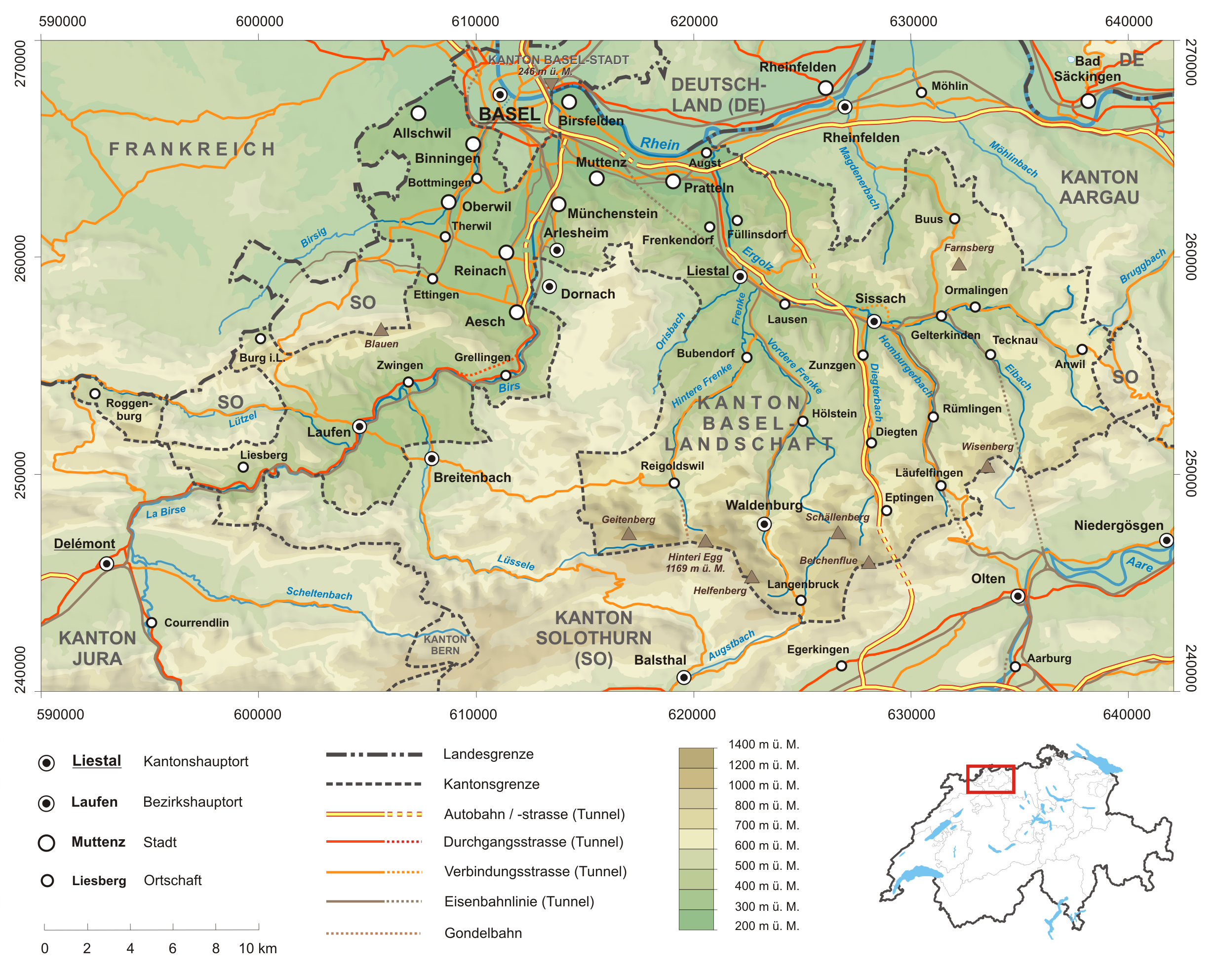
Deutsch: Karte des Kanton Basel-Landschaft.
Topographischer Hintergrund: NASA Shuttle Radar Topography Mission (public domain). SRTM3 v.2. |
||||||||
| Datum | |||||||||
| Quälle | Eigeni Arbet | ||||||||
| Urheber | Tschubby | ||||||||
| Gnähmigung (Wyternutzig vu däre Datei) |
Ich haa s Urheberrächt an däm Wärch un vereffetlig s dodermit unter däne Lizänze:
Die Datei isch lizänziert unter dr Creative-Commons-Lizänze Namensnännig – Wytergab unter glyche Bedingige 2.5 generisch, 2.0 generisch un 1.0 generisch.
Du chasch sälber e Lizänz uuswehle. |
||||||||
| Anderi Versione |
|


Dateiversione
Klick uf e Zytpunkt zu aazeige, wie s dert usgsäh het.
| Version vom | Vorschaubild | Mäß | Benutzer | Kommentar | |
|---|---|---|---|---|---|
| aktuell | 06:06, 31. Mai 2008 | | 2.461 × 1.964 (3,54 MB) | Tschubby | {{Information |Description= |Source=eigene Arbeit |Date= |Author= Tschubby |Permission= |other_versions= }} |
| 06:02, 31. Mai 2008 |  | 3.543 × 4.991 (7,06 MB) | Tschubby | {{Information |Description= |Source=eigene Arbeit |Date= |Author= Tschubby |Permission= |other_versions= }} | |
| 19:41, 30. Mai 2008 |  | 2.461 × 1.966 (3,54 MB) | Tschubby | {{Information |Description= |Source=eigene Arbeit |Date= |Author= Tschubby |Permission= |other_versions= }} | |
| 18:05, 29. Mai 2008 |  | 2.458 × 1.965 (3,53 MB) | Tschubby | {{Information |Description= |Source=eigene Arbeit |Date= |Author= Tschubby |Permission= |other_versions= }} | |
| 21:23, 28. Mai 2008 |  | 2.460 × 1.965 (3,49 MB) | Tschubby | {{Information |Description= {{de| Karte des Kanton Basel-Landschaft.}} Topographischer Hintergrund: [http://www2.jpl.nasa.gov/srtm NASA Shuttle Radar Topography Mission] (public domain). SRTM3 v.2. |Source=eigene Arbeit |Da |
Verwändig vu dr Datei
Di folgende Sytene händ en Link zu dem Bildli:
Wältwyti Dateinutzig
Die andere Wikis bruche die Datei:
- Gebruch uf de.wikipedia.org
- Gebruch uf de.wikivoyage.org
- Gebruch uf eo.wikipedia.org
- Gebruch uf sk.wikipedia.org
- Gebruch uf sr.wikipedia.org