
Datei:Iran relief location map.jpg

Greßi vu däre Vorschau: 672 × 600 Pixel. Wyteri Ufflösige: 269 × 240 Pixel | 538 × 480 Pixel | 861 × 768 Pixel | 1.200 × 1.071 Pixel.
Originaldatei (1.200 × 1.071 Pixel, Dateigrößi: 941 KB, MIME-Typ: image/jpeg)
| Die Datei un d Informatione derzue were us em zäntrale Mediearchiv Wikimedia Commons (Allmänd) iibunde. | Zur Bschriibigssite uff de Allmänd |
Bschryybig
| Bschryybig |
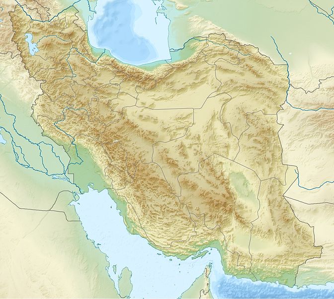
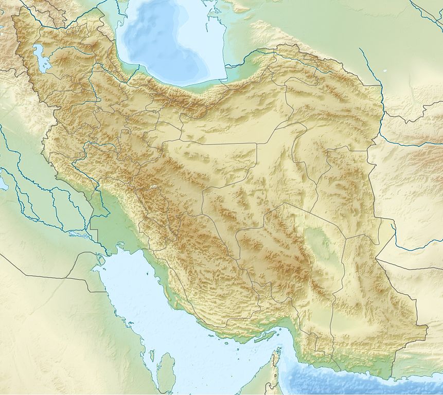
English: Location map of Iran.
Equirectangular projection. Strechted by 118.0%. Geographic limits of the map: * N: 40.0° N * S: 24.5° N * W: 43.5° E * E: 64.0° EMade with Natural Earth. Free vector and raster map data @ naturalearthdata.com. Deutsch: Topografische Karte des Iranischen Hochlandes mit der Verbindung zu Kleinasien im Westen und zum Hindukusch und Himalaya im Osten.
English: Topographic map of the Iranian plateau in Central Asia, connecting to Anatolia in the west and Hindu Kush and Himalaya in the east.
Español: Mapa topográfico de la Meseta iraní. Mapa topográfico de la meseta iraní que enlaza Anatolia en el oeste con el Hindu Kush y el Himalaya en el Este.
Euskara: Irango goi-ordokiaren mapa topografikoa, Anatolia mendebaldean eta Hindu Kush eta Himalaia ekialdean.
فارسی: فلات ایران سرزمین مرتفعی است در همسایگی مناطق کم ارتفاع غرب، شمال و جنوب آسیا.
Français : Carte du plateau iranien en Asie, lié à l'Anatolie à l'ouest, et à l'Hindu Kush et à l'Himalaya à l'est.
한국어: 이란 고원의 서쪽으로는 아나톨리아로 연결되고, 동쪽으로는 힌두쿠시 산맥와 히말라야 산맥과 연결된다.
Nederlands: Kaart van het Hoogland van Iran in Azië, dat zich uitstrekt van Anatolië in het westen tot aan de Hindoekoesj en de Himalaya in het oosten.
Norsk bokmål: Topografisk kart over det iranske høylandet, som grenser til Anatolia i vest og Hindu Kush og Himalaya i øst.
پنجابی: سطح مرتفع ایران دا نقشہ ، لہندے چ اناطولیا تے چڑھدے چ کوہ ہندوکش تے ہمالیہ نال جڑئیا.
Português: Mapa topográfico do planalto iraniano ligando a Anatólia a oeste e o Hindu Kush e os Himalaias a este.
Русский: Иранское нагорье располагается между Аравийским полуостровом на западе и севером Индийского субконтинента на востоке.
Türkçe: Batıda Anadolu'ya doğuda ise Hindukuş ve Himalaya dağlarına bağlanan İran platosunun topografik haritası.
اردو: سطع مرتفع ایران کا نقشہ، مغرب میں اناطولیہ اور مشرق میں ہندوکش اور ہمالیہ سے منسلک.
Tiếng Việt: Bản đồ địa hình với sơn nguyên Iran nối Anatolia ở phía tây với Hindu Kush và Himalaya ở phía đông.
中文:伊朗高原地形圖,連接安納托利亞西部,東與喜馬拉雅山相鄰. |
| Datum | |
| Quälle | Eigeni Arbet |
| Urheber | Uwe Dedering |
| Anderi Versione |
|


Lizänzierig
Ich haa s Urheberrächt an däm Wärch un vereffetlig s dodermit unter däne Lizänze:
Die Datei isch lizänziert unter dr Creative-Commons-Lizenz Namensnännig – Wytergab unter glyche Bedingige 3.0 nit portiert.
- Du derfsch:
- des Wärch an anderi wytergee – des Wärch kopiere, verbreite un ibertrage
- des Wärch verändere – des Wärch aapasse
- Unter däne Bedingige:
- Namenännig – Du muesch aagmässeni Aagabe zum Urheber un dr Rächt mache, e Link zue dr Lizänz zuefiege un aagee, eb Änderige gmacht wore sin. Die Aagabe chenne in ere aagmässene Art gmacht wäre, aber nit eso, ass dr Yydruck entstoht, ass dr Lizänzgeber Dii oder Dyy Gebruch vum Wärch unterstitze un guetheiße.
- Wytergab unter glyche Bedingige – Wänn du des Wärch veränderesch, umwandlesch oder druf ufböusch, no derfsch s Ergebnis nume unter dr glyche oder ere kumpatible Lizänz wie s Orginal vereffetlige.

|
Des Dokumänt derf kopiert, verbreitet un/oder bearbeitet wäre unter dr Bedingige vu dr GNU-Lizänz fir freji Dokumäntation, Version 1.2 oder ere spetere Version, vereffetligt dur Free Software Foundation. S het keini uuveränderlige Abschnitt, kei vordere Umschlagstext un kei hindere Umschlagstext. E Kopii vu dr Lizänz isch verfiegbar im Abschnitt GNU-Lizänz fir freji Dokumäntation. |
Du chasch sälber e Lizänz uuswehle.
Dateiversione
Klick uf e Zytpunkt zu aazeige, wie s dert usgsäh het.
| Version vom | Vorschaubild | Mäß | Benutzer | Kommentar | |
|---|---|---|---|---|---|
| aktuell | 22:09, 11. Jul. 2010 | | 1.200 × 1.071 (941 KB) | Uwe Dedering | 31. province Alborz |
| 17:51, 23. Apr. 2010 |  | 1.200 × 1.071 (941 KB) | Uwe Dedering | {{Information |Description={{en|1=Location map of Iran. Equirectangular projection. Strechted by 118.0%. Geographic limits of the map: * N: 40.0° N * S: 24.5° N * W: 43.5° E * E: 64.0° E Made with Natural Earth. Free vector and raster map data @ |
Verwändig vu dr Datei
Di folgende Sytene händ en Link zu dem Bildli:
Wältwyti Dateinutzig
Die andere Wikis bruche die Datei:
- Gebruch uf ar.wikipedia.org
- Gebruch uf ary.wikipedia.org
- Gebruch uf ast.wikipedia.org
- Gebruch uf av.wikipedia.org
- Gebruch uf azb.wikipedia.org
- Gebruch uf az.wikipedia.org
Wältwyti Verwändig vu däre Datei aaluege.