
Datei:Fly River Map 1876 NLA.jpg

Greßi vu däre Vorschau: 800 × 533 Pixel. Wyteri Ufflösige: 320 × 213 Pixel | 640 × 427 Pixel | 1.024 × 683 Pixel | 1.280 × 853 Pixel | 1.950 × 1.300 Pixel.
Originaldatei (1.950 × 1.300 Pixel, Dateigrößi: 475 KB, MIME-Typ: image/jpeg)
| Die Datei un d Informatione derzue were us em zäntrale Mediearchiv Wikimedia Commons (Allmänd) iibunde. | Zur Bschriibigssite uff de Allmänd |
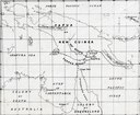
| Bschryybig | Fly river, Papua New Guinea: as surveyed by L. M. D'Albertis on board the steam launch "Neva" 1876 |
| Datum | |
| Quälle | http://www.nla.gov.au/apps/cdview?pi=nla.map-f469-sd |
| Urheber | L. M. D'Albertis |
| Anderi Versione |
Dieses Bild ist gemeinfrei, weil sein Urheberrecht in Australien abgelaufen ist. Nach dem Informationsblatt über Urheberrecht des ACC (Januar 2019) ist dies in folgenden Fällen der Fall:
Beim Benutzen dieser Vorlage bitte immer angeben, wo das Werk veröffentlicht wurde und wer es erstellt hat. |
 |
Dateiversione
Klick uf e Zytpunkt zu aazeige, wie s dert usgsäh het.
| Version vom | Vorschaubild | Mäß | Benutzer | Kommentar | |
|---|---|---|---|---|---|
| aktuell | 06:27, 24. Jul. 2007 | | 1.950 × 1.300 (475 KB) | Nomadtales | {{Information |Description=Fly river, Papua New Guinea: as surveyed by L. M. D'Albertis on board the steam launch "Neva" 1876 |Source=http://www.nla.gov.au/apps/cdview?pi=nla.map-f469-sd |Date=1876 |Author=L. M. D'Albertis |Permission= |other_versions= }} |
Verwändig vu dr Datei
Di folgende Sytene händ en Link zu dem Bildli:
Wältwyti Dateinutzig
Die andere Wikis bruche die Datei:
- Gebruch uf ast.wikipedia.org
- Gebruch uf az.wikipedia.org
- Gebruch uf ca.wikipedia.org
- Gebruch uf cv.wikipedia.org
- Gebruch uf de.wikipedia.org
- Gebruch uf en.wikipedia.org
- Gebruch uf eo.wikipedia.org
- Gebruch uf es.wikipedia.org
- Gebruch uf hy.wikipedia.org
- Gebruch uf id.wikipedia.org
- Gebruch uf ml.wikipedia.org
- Gebruch uf nl.wikipedia.org
- Gebruch uf no.wikipedia.org
- Gebruch uf pt.wikipedia.org
- Gebruch uf ru.wikipedia.org
- Gebruch uf zh.wikipedia.org