
Datei:Euskal herriko iparraldea 128kolore.png

Greßi vu däre Vorschau: 625 × 599 Pixel. Wyteri Ufflösige: 250 × 240 Pixel | 501 × 480 Pixel | 801 × 768 Pixel | 1.068 × 1.024 Pixel | 1.400 × 1.342 Pixel.
Originaldatei (1.400 × 1.342 Pixel, Dateigrößi: 441 KB, MIME-Typ: image/png)
| Die Datei un d Informatione derzue were us em zäntrale Mediearchiv Wikimedia Commons (Allmänd) iibunde. | Zur Bschriibigssite uff de Allmänd |
Bschryybig
| Bschryybig |
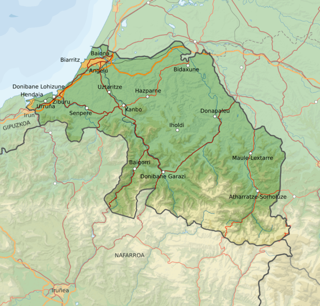
English: Map of North Basque Country (French side)
Euskara: Ipar Euskal Herriko mapa |
| Datum | |
| Quälle | Own work, based on Pyrenees-Atlantiques topographic map-fr.jpg |
| Urheber | Asier Sarasua Garmendia |
Lizänzierig
Die Datei isch lizänziert unter dr Creative-Commons-Lizenz Namensnännig – Wytergab unter glyche Bedingige 3.0 nit portiert.
- Du derfsch:
- des Wärch an anderi wytergee – des Wärch kopiere, verbreite un ibertrage
- des Wärch verändere – des Wärch aapasse
- Unter däne Bedingige:
- Namenännig – Du muesch aagmässeni Aagabe zum Urheber un dr Rächt mache, e Link zue dr Lizänz zuefiege un aagee, eb Änderige gmacht wore sin. Die Aagabe chenne in ere aagmässene Art gmacht wäre, aber nit eso, ass dr Yydruck entstoht, ass dr Lizänzgeber Dii oder Dyy Gebruch vum Wärch unterstitze un guetheiße.
- Wytergab unter glyche Bedingige – Wänn du des Wärch veränderesch, umwandlesch oder druf ufböusch, no derfsch s Ergebnis nume unter dr glyche oder ere kumpatible Lizänz wie s Orginal vereffetlige.
Dateiversione
Klick uf e Zytpunkt zu aazeige, wie s dert usgsäh het.
| Version vom | Vorschaubild | Mäß | Benutzer | Kommentar | |
|---|---|---|---|---|---|
| aktuell | 17:38, 13. Aug. 2008 | | 1.400 × 1.342 (441 KB) | Assar | {{Information |Description={{en|1=Map of North Basque Country (French side)}} {{eu|1=Ipar Euskal Herriko mapa}} |Source=Own work, based on |Author=Asier Sarasua Garmendia |Date=2008/08/13 |Permission= |other_versions= }} <!--{{ImageUpload|full}}--> [[Ca |
Verwändig vu dr Datei
Di folgende Sytene händ en Link zu dem Bildli:
Wältwyti Dateinutzig
Die andere Wikis bruche die Datei:
- Gebruch uf de.wikipedia.org
- Gebruch uf el.wikipedia.org
- Gebruch uf eu.wikipedia.org
- Gebruch uf fi.wikipedia.org
- Gebruch uf hr.wikipedia.org
- Gebruch uf sv.wikipedia.org