
Datei:Colombia relief location map.jpg

Greßi vu däre Vorschau: 530 × 600 Pixel. Wyteri Ufflösige: 212 × 240 Pixel | 424 × 480 Pixel | 679 × 768 Pixel | 905 × 1.024 Pixel | 2.028 × 2.294 Pixel.
Originaldatei (2.028 × 2.294 Pixel, Dateigrößi: 1,1 MB, MIME-Typ: image/jpeg)
| Die Datei un d Informatione derzue were us em zäntrale Mediearchiv Wikimedia Commons (Allmänd) iibunde. | Zur Bschriibigssite uff de Allmänd |
Bschryybig


.svg)


|
Diese Karte wurde in der Kartenwerkstatt erstellt oder verbessert. Auch du kannst dort Karten vorschlagen, die zu erstellen, verändern oder übersetzen sind.
|
Lizänzierig
Ich haa s Urheberrächt an däm Wärch un vereffetlig s dodermit unter däre Lizänz:
Die Datei isch lizänziert unter dr Creative-Commons-Lizenz Namensnännig – Wytergab unter glyche Bedingige 3.0 nit portiert.
- Du derfsch:
- des Wärch an anderi wytergee – des Wärch kopiere, verbreite un ibertrage
- des Wärch verändere – des Wärch aapasse
- Unter däne Bedingige:
- Namenännig – Du muesch aagmässeni Aagabe zum Urheber un dr Rächt mache, e Link zue dr Lizänz zuefiege un aagee, eb Änderige gmacht wore sin. Die Aagabe chenne in ere aagmässene Art gmacht wäre, aber nit eso, ass dr Yydruck entstoht, ass dr Lizänzgeber Dii oder Dyy Gebruch vum Wärch unterstitze un guetheiße.
- Wytergab unter glyche Bedingige – Wänn du des Wärch veränderesch, umwandlesch oder druf ufböusch, no derfsch s Ergebnis nume unter dr glyche oder ere kumpatible Lizänz wie s Orginal vereffetlige.
Dateiversione
Klick uf e Zytpunkt zu aazeige, wie s dert usgsäh het.
| Version vom | Vorschaubild | Mäß | Benutzer | Kommentar | |
|---|---|---|---|---|---|
| aktuell | 08:53, 16. Feb. 2015 | | 2.028 × 2.294 (1,1 MB) | Milenioscuro | same dimensions of locator map.svg |
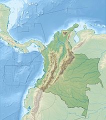
| 14:38, 6. Feb. 2010 |  | 1.516 × 1.736 (901 KB) | Alexrk2 | {{Information |Description= {{de|Physische Positionskarte von Kolumbien Quadratische Plattkarte. Geographische Begrenzung der Karte:}} {{en|Physical Location map of Colombia Equirectangular projection. Geographic limits |
Verwändig vu dr Datei
Di folgende Sytene händ en Link zu dem Bildli:
Wältwyti Dateinutzig
Die andere Wikis bruche die Datei:
- Gebruch uf ar.wikipedia.org
- Gebruch uf ast.wikipedia.org
- Gebruch uf avk.wikipedia.org
- Gebruch uf azb.wikipedia.org
- Gebruch uf az.wikipedia.org
- Gebruch uf ban.wikipedia.org
- Gebruch uf ba.wikipedia.org
- Gebruch uf be.wikipedia.org
- Gebruch uf bg.wikipedia.org
Wältwyti Verwändig vu däre Datei aaluege.