
Datei:Okhotsk Plate map - de.png
Greßi vu däre Vorschau: 443 × 600 Pixel. Wyteri Ufflösige: 177 × 240 Pixel | 628 × 850 Pixel.
Originaldatei (628 × 850 Pixel, Dateigrößi: 93 KB, MIME-Typ: image/png)
| Die Datei un d Informatione derzue were us em zäntrale Mediearchiv Wikimedia Commons (Allmänd) iibunde. | Zur Bschriibigssite uff de Allmänd |
| Bschryybig |
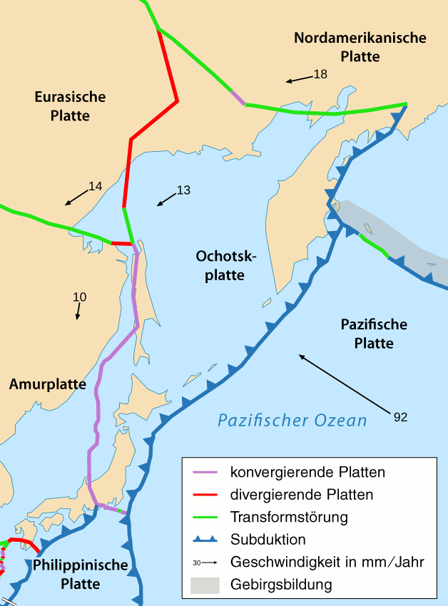
Deutsch: Das tektonische Gebiet rund um die Ochotskplatte.
English: Area around Okhotsk plate. |
||
| Datum | see file history | ||
| Quälle | |||
| Urheber |
|
||
| Gnähmigung (Wyternutzig vu däre Datei) |
Ich haa s Urheberrächt an däm Wärch un vereffetlig s dodermit unter däre Lizänz: Die Datei isch lizänziert unter dr Creative-Commons-Lizenz Namensnännig – Wytergab unter glyche Bedingige 2.5 generisch.
|
||
| Anderi Versione |
|
Dateiversione
Klick uf e Zytpunkt zu aazeige, wie s dert usgsäh het.
| Version vom | Vorschaubild | Mäß | Benutzer | Kommentar | |
|---|---|---|---|---|---|
| aktuell | 21:54, 14. Mär. 2011 | | 628 × 850 (93 KB) | Chumwa | Philippinenseeplatte → Philippinische Platte |
| 08:47, 13. Mär. 2011 |  | 628 × 850 (94 KB) | Chumwa | Schrift | |
| 08:42, 13. Mär. 2011 |  | 628 × 850 (92 KB) | Chumwa | Schrift | |
| 08:39, 13. Mär. 2011 |  | 628 × 850 (92 KB) | Chumwa | Information |Description={{de|Das tektonische Gebiet rund um die Ochotskplatte.}} {{en|Area around Okhotsk plate.}} |Source=*Tectonic_plates_boundaries_detailed-fr.svg |Date=see file hist |
Verwändig vu dr Datei
Di folgende Sytene händ en Link zu dem Bildli:
Wältwyti Dateinutzig
Die andere Wikis bruche die Datei:
- Gebruch uf be.wikipedia.org
- Gebruch uf de.wikipedia.org
- Gebruch uf rm.wikipedia.org
- Gebruch uf ru.wikipedia.org