
Datei:Narva basin map.svg

Gröössi vor PNG-Vorschou vor SVG-Datei: 423 × 599 Pixel. Wyteri Ufflösige: 169 × 240 Pixel | 339 × 480 Pixel | 542 × 768 Pixel | 722 × 1.024 Pixel | 1.445 × 2.048 Pixel | 743 × 1.053 Pixel.
Originaldatei (SVG-Datei, Basisgrößi: 743 × 1.053 Pixel, Dateigrößi: 2,46 MB)
| Die Datei un d Informatione derzue were us em zäntrale Mediearchiv Wikimedia Commons (Allmänd) iibunde. | Zur Bschriibigssite uff de Allmänd |
Bschryybig
| Bschryybig |
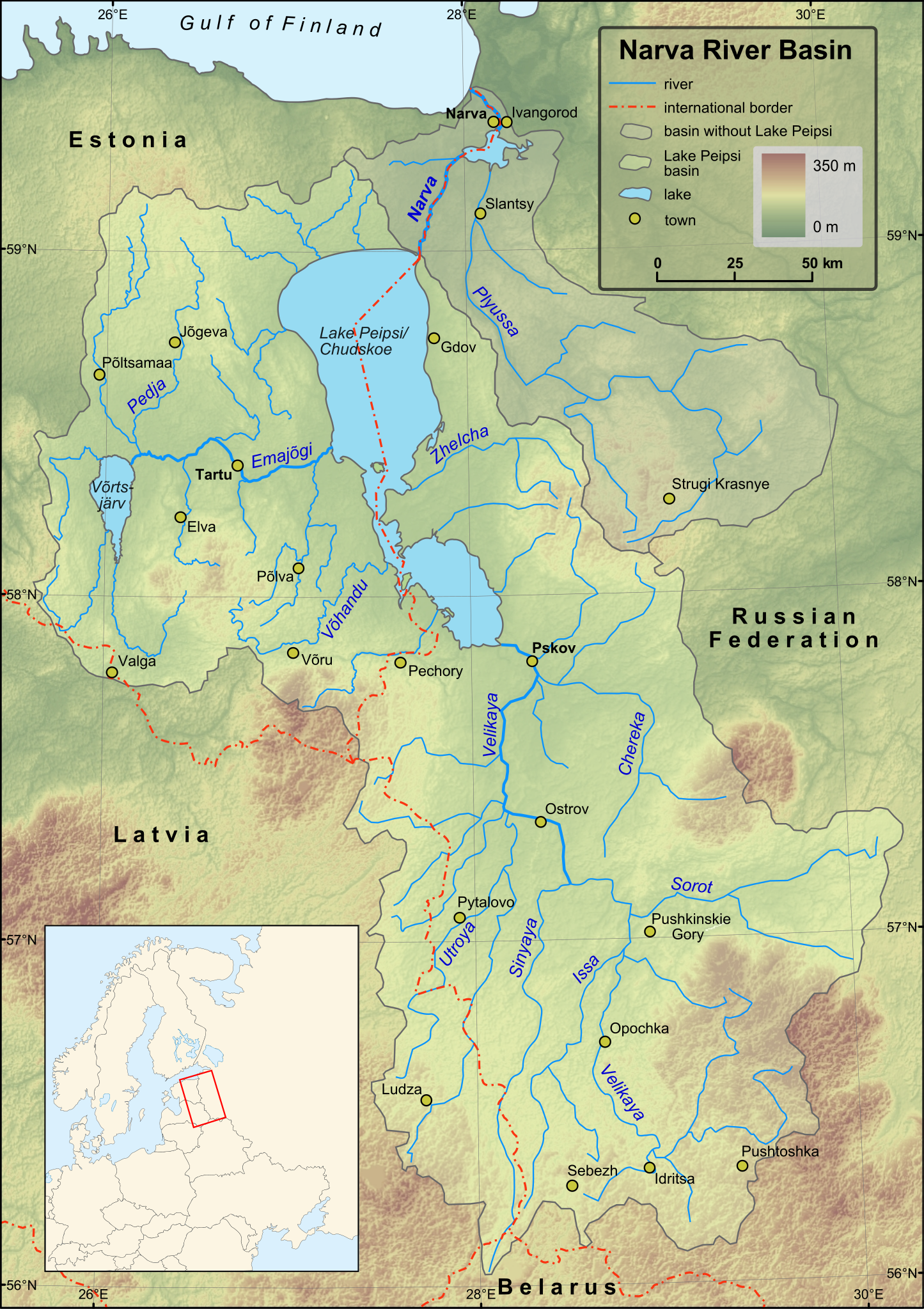
English: Map of Narva River and Lake Peipsi basins. Towns with population over 4000 (according to relevant Wikipedia lists) are included on the map. Terrain: embedded JPG. Projection: UTM Zone 35N |
| Datum | |
| Quälle |
Created in ESRI ArcMap and Inkscape using a map from [1] and some other maps for corrections.
Elevation data from Shuttle Radar Topography Mission. |
| Urheber | Hannu |
| Anderi Versione | Magyar |
Lizänzierig
| Ich, dr Urheberrächtsinhaber vu däm Wärch, tue s as gmeinfrej vereffentlige . Des giltet wältwyt. In mänke Staate chennt des rächtli nit megli syy. Wänn des imfall eso isch: Ich gib e jedem s bedingiglos Rächt, des Wärch jedwädere Zwäck z nutze, ußer s git gesetzlig erforderligi Bedingige. |
Dateiversione
Klick uf e Zytpunkt zu aazeige, wie s dert usgsäh het.
| Version vom | Vorschaubild | Mäß | Benutzer | Kommentar | |
|---|---|---|---|---|---|
| aktuell | 18:43, 1. Dez. 2009 | | 743 × 1.053 (2,46 MB) | Hannu~commonswiki | minor updates |
| 02:53, 28. Nov. 2009 |  | 743 × 1.053 (2,44 MB) | Hannu~commonswiki | : | |
| 02:35, 28. Nov. 2009 |  | 743 × 1.053 (2,44 MB) | Hannu~commonswiki | text to path | |
| 02:19, 28. Nov. 2009 |  | 743 × 1.053 (2,06 MB) | Hannu~commonswiki | : | |
| 02:14, 28. Nov. 2009 |  | 743 × 1.053 (2,05 MB) | Hannu~commonswiki | new map | |
| 20:53, 14. Apr. 2009 |  | 738 × 1.004 (959 KB) | Hannu~commonswiki | vector location map | |
| 17:28, 17. Jan. 2009 |  | 738 × 1.004 (957 KB) | Hannu~commonswiki | {{Information |Description={{en|1=Map of Narva River and Lake Peipsi basins.}} |Source=Created in Inkscape using a map from [http://www.ilec.or.jp/eg/lbmi/pdf/20_Lake_Peipsi_Chudskoe_27February2006.pdf]. Location ma | |
| 18:18, 16. Jan. 2009 |  | 738 × 1.004 (639 KB) | Hannu~commonswiki | {{Information |Description={{en|1=Map of Narva River and Lake Peipsi basins.}} |Source=Created in Inkscape using a map from [http://www.ilec.or.jp/eg/lbmi/pdf/20_Lake_Peipsi_Chudskoe_27February2006.pdf]. Minimap mad | |
| 18:11, 16. Jan. 2009 |  | 738 × 1.004 (529 KB) | Hannu~commonswiki | {{Information |Description={{en|1=Map of Narva River and Lake Peipsi basins.}} |Source=Created in Inkscape using a map from [http://www.ilec.or.jp/eg/lbmi/pdf/20_Lake_Peipsi_Chudskoe_27February2006.pdf]. Minimap mad |
Verwändig vu dr Datei
Di folgende Sytene händ en Link zu dem Bildli:
Wältwyti Dateinutzig
Die andere Wikis bruche die Datei:
- Gebruch uf af.wikipedia.org
- Gebruch uf ar.wikipedia.org
- Gebruch uf ast.wikipedia.org
- Gebruch uf azb.wikipedia.org
- Gebruch uf be-tarask.wikipedia.org
- Gebruch uf bg.wikipedia.org
- Gebruch uf ca.wikipedia.org
- Gebruch uf cs.wikipedia.org
- Gebruch uf da.wikipedia.org
- Gebruch uf de.wikipedia.org
- Gebruch uf el.wikipedia.org
- Gebruch uf en.wikipedia.org
- Gebruch uf es.wikipedia.org
- Gebruch uf fa.wikipedia.org
- Gebruch uf fi.wikipedia.org
- Luokka:Narvanjoen vesistö
- Velikaja
- Pljussa
- Piusa jõgi
- Narvanjoen vesistöalue
- Luokka:Narvanjoen alue
- Narvanjoen alue
- Janja (Pljussa)
- Ljuta (Pljussa)
- Vjorduga
- Pljussan valuma-alue
- Kureja
- Pihkovanjoki
- Luokka:Velikajan valuma-alue
- Tšerjoha (joki)
- Haanjan ylänkö
- Alūksnen ylänkö
- Želtša
- Velikajan valuma-alue
- Peipsijärven valuma-alue
- Luokka:Peipsijärven valuma-alue
- Peipsijärven alue
- Luokka:Emajoen alue
- Luokka:Võrtsjärven valuma-alue
- Võhandu jõgi
- Emajoen valuma-alue
- Luokka:Emajoen valuma-alue
Wältwyti Verwändig vu däre Datei aaluege.