
Datei:Karta PG Trobriand isl.PNG
Kei höcheri Uflösig verfüegbar.
Karta_PG_Trobriand_isl.PNG (300 × 200 Pixel, Dateigrößi: 4 KB, MIME-Typ: image/png)
| Die Datei un d Informatione derzue were us em zäntrale Mediearchiv Wikimedia Commons (Allmänd) iibunde. | Zur Bschriibigssite uff de Allmänd |
Bschryybig
| Bschryybig |
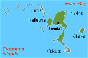
English: Map (rough) of Trobriand islands, Papua New Guinea, own work composed from various mapreferences |
| Datum | |
| Quälle | Eigeni Arbet |
| Urheber | Hobe / Holger Behr |
Lizänzierig
| Ich, dr Urheberrächtsinhaber vu däm Wärch, tue s as gmeinfrej vereffentlige . Des giltet wältwyt. In mänke Staate chennt des rächtli nit megli syy. Wänn des imfall eso isch: Ich gib e jedem s bedingiglos Rächt, des Wärch jedwädere Zwäck z nutze, ußer s git gesetzlig erforderligi Bedingige. |
Dateiversione
Klick uf e Zytpunkt zu aazeige, wie s dert usgsäh het.
| Version vom | Vorschaubild | Mäß | Benutzer | Kommentar | |
|---|---|---|---|---|---|
| aktuell | 17:52, 12. Mai 2007 | | 300 × 200 (4 KB) | Hobe | {{Information |Description=map Trobriand islands, Papua New Guinea |Source=own work, composed from various mapreferences |Date=2007-04-25 |Author=Holger Behr |Permission= |other_versions= }} |
Verwändig vu dr Datei
Di folgende Sytene händ en Link zu dem Bildli:
Wältwyti Dateinutzig
Die andere Wikis bruche die Datei:
- Gebruch uf de.wikipedia.org
- Gebruch uf en.wikipedia.org
- Gebruch uf eo.wikipedia.org
- Gebruch uf es.wikipedia.org
- Gebruch uf fa.wikipedia.org
- Gebruch uf frr.wikipedia.org
- Gebruch uf gl.wikipedia.org
- Gebruch uf it.wikipedia.org
- Gebruch uf ja.wikipedia.org
- Gebruch uf ka.wikipedia.org
- Gebruch uf nl.wikipedia.org
- Gebruch uf pnb.wikipedia.org
- Gebruch uf sv.wikipedia.org
- Gebruch uf zh.wikipedia.org