
Datei:Federation of Rhodesia and Nyasaland map 1960.jpg

Greßi vu däre Vorschau: 556 × 599 Pixel. Wyteri Ufflösige: 223 × 240 Pixel | 445 × 480 Pixel | 712 × 768 Pixel | 950 × 1.024 Pixel | 1.900 × 2.048 Pixel | 3.436 × 3.704 Pixel.
Originaldatei (3.436 × 3.704 Pixel, Dateigrößi: 9,76 MB, MIME-Typ: image/jpeg)
| Die Datei un d Informatione derzue were us em zäntrale Mediearchiv Wikimedia Commons (Allmänd) iibunde. | Zur Bschriibigssite uff de Allmänd |
Bschryybig
| Bschryybig |
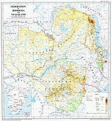
English: A map of the Federation of Rhodesia and Nyasaland, issued by the Government in 1960 |
| Datum | |
| Quälle | Originally scanned from Government-issue Federal Atlas issued in 1960. Scan taken from Great North Road website. |
| Urheber | Federal Government Printer, Salisbury, Rhodesia and Nyasaland. Copyright owned by the Government of Federation of Rhodesia and Nyasaland |
| Anderi Versione |
Lizänzierig
This work was first published in Zimbabwe (or one of its antecedents) and is now in the public domain in Zimbabwe because its copyright protection has expired by virtue of the Copyright and Neighboring Rights Act, enacted 2000 (details). The work meets one of the following criteria:
A Zimbabwean work that is in the public domain in Zimbabwe according to this rule is in the public domain in the U.S. only if it was in the public domain in Zimbabwe in 1996, e.g. if it was published before 1946 and no copyright was registered in the U.S. (This is the effect of the Uruguay Round Agreements Act (17 USC 104A) with its critical date of January 1, 1996.) |
 |
Dateiversione
Klick uf e Zytpunkt zu aazeige, wie s dert usgsäh het.
| Version vom | Vorschaubild | Mäß | Benutzer | Kommentar | |
|---|---|---|---|---|---|
| aktuell | 23:43, 28. Nov. 2011 | | 3.436 × 3.704 (9,76 MB) | P. S. Burton | removed watermark, and slight crop of frame |
| 03:50, 20. Okt. 2011 |  | 3.436 × 3.757 (2,76 MB) | Renamed user df576567etesddf | restored watermark per request on website; also file is smaller | |
| 03:14, 20. Okt. 2011 |  | 3.436 × 3.695 (9,23 MB) | Renamed user df576567etesddf | {{Information |Description ={{en|1=A map of the Federation of Rhodesia and Nyasaland, issued by the Government in 1960}} |Source =Originally scanned from Government-issue Federal Atlas issued in 1960. Scan taken from [http://www.greatnorthroad. |
Verwändig vu dr Datei
Di folgende Sytene händ en Link zu dem Bildli:
Wältwyti Dateinutzig
Die andere Wikis bruche die Datei:
- Gebruch uf de.wikipedia.org
- Gebruch uf en.wikipedia.org
- Gebruch uf en.wikibooks.org
- Gebruch uf es.wikipedia.org
- Gebruch uf mt.wikipedia.org
- Gebruch uf pl.wikipedia.org
- Gebruch uf tum.wikipedia.org