
Datei:False color of Hellas Planitia.jpeg

Greßi vu däre Vorschau: 486 × 599 Pixel. Wyteri Ufflösige: 195 × 240 Pixel | 389 × 480 Pixel | 623 × 768 Pixel | 831 × 1.024 Pixel | 1.909 × 2.353 Pixel.
Originaldatei (1.909 × 2.353 Pixel, Dateigrößi: 881 KB, MIME-Typ: image/jpeg)
| Die Datei un d Informatione derzue were us em zäntrale Mediearchiv Wikimedia Commons (Allmänd) iibunde. | Zur Bschriibigssite uff de Allmänd |
Bschryybig
| Bschryybig |
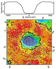
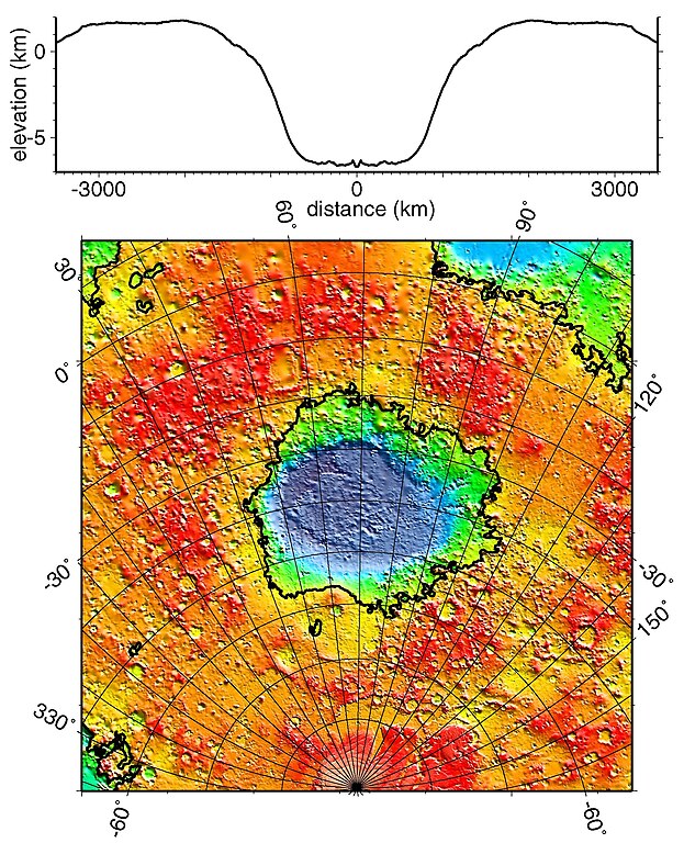
English: Regional topographic model of the Hellas basin (Hellas Planitia) taken by the MOLA instrument aboard the Mars Global Surveyor. (Top) Azimuthally-averaged radial topography used in the calculation of infilling the basin with surrounding material postulated to have been excavated from it. (Bottom) Color-coded topography plotted in an equal-area projection. The black lines correspond to zero-elevation contours. |
| Datum | |
| Quälle | http://photojournal.jpl.nasa.gov/catalog/PIA02033 |
| Urheber | NASA/JPL/GSFC |
Lizänzierig
| Diese Datei ist gemeinfrei (public domain), da sie von der NASA erstellt worden ist. Die NASA-Urheberrechtsrichtlinie besagt, dass „NASA-Material nicht durch Urheberrecht geschützt ist, wenn es nicht anders angegeben ist“. (NASA-Urheberrechtsrichtlinie-Seite oder JPL Image Use Policy). | ||
 |
Warnung:
|
Dateiversione
Klick uf e Zytpunkt zu aazeige, wie s dert usgsäh het.
| Version vom | Vorschaubild | Mäß | Benutzer | Kommentar | |
|---|---|---|---|---|---|
| aktuell | 20:51, 19. Dez. 2010 | | 1.909 × 2.353 (881 KB) | Orionist | high res version from original source |
| 01:42, 3. Feb. 2006 |  | 274 × 337 (78 KB) | W-j-s | Hellas Planitia, NASA From [http://rst.gsfc.nasa.gov/Sect19/Sect19_12.html] {{PD-USGov-NASA}} |
Verwändig vu dr Datei
Di folgende Sytene händ en Link zu dem Bildli:
Wältwyti Dateinutzig
Die andere Wikis bruche die Datei:
- Gebruch uf ca.wikipedia.org
- Gebruch uf de.wikipedia.org
- Gebruch uf el.wikipedia.org
- Gebruch uf en.wikipedia.org
- Gebruch uf fr.wikipedia.org
- Gebruch uf gl.wikipedia.org
- Gebruch uf hy.wikipedia.org
- Gebruch uf it.wikipedia.org
- Gebruch uf ja.wikipedia.org
- Gebruch uf lb.wikipedia.org
- Gebruch uf ml.wikipedia.org
- Gebruch uf pnb.wikipedia.org
- Gebruch uf pt.wikipedia.org
- Gebruch uf ro.wikipedia.org
- Gebruch uf ru.wikipedia.org
- Gebruch uf uk.wikipedia.org
- Gebruch uf ur.wikipedia.org
- Gebruch uf zh.wikipedia.org