
Datei:Biafra independent state map-de.svg

Gröössi vor PNG-Vorschou vor SVG-Datei: 776 × 600 Pixel. Wyteri Ufflösige: 311 × 240 Pixel | 621 × 480 Pixel | 994 × 768 Pixel | 1.280 × 989 Pixel | 2.560 × 1.978 Pixel | 1.100 × 850 Pixel.
Originaldatei (SVG-Datei, Basisgrößi: 1.100 × 850 Pixel, Dateigrößi: 455 KB)
| Die Datei un d Informatione derzue were us em zäntrale Mediearchiv Wikimedia Commons (Allmänd) iibunde. | Zur Bschriibigssite uff de Allmänd |

|
Diese SVG-Datei enthält eingebetteten Text, der mit jedem geeigneten SVG-Editor, Texteditor oder dem SVG-Übersetzungs-Werkzeug in deine Sprache übersetzt werden kann. Für mehr Informationen siehe Über das Übersetzen von SVG-Dateien. |
Bschryybig
| Bschryybig |
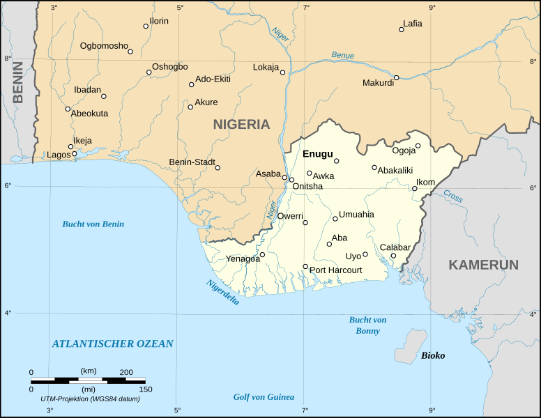
English: Map of the secessionist state of the Republic of Biafra (1967 – 1970) as in May 1967.
Note: The western boundary may not be accurate due to the low precision of the reference maps used which are also contradictory. UTM projection ; WGS 84 datum |
| Datum | September 2008 (new version) |
| Quälle |
Own work
|
| Urheber | Eric Gaba (Sting - fr:Sting), Translation: Bohr |
| Gnähmigung (Wyternutzig vu däre Datei) |
GFDL + CC-BY-SA |
| Anderi Versione |
[]
|


Lizänzierig

|
Des Dokumänt derf kopiert, verbreitet un/oder bearbeitet wäre unter dr Bedingige vu dr GNU-Lizänz fir freji Dokumäntation, Version 1.2 oder ere spetere Version, vereffetligt dur Free Software Foundation. S het keini uuveränderlige Abschnitt, kei vordere Umschlagstext un kei hindere Umschlagstext. E Kopii vu dr Lizänz isch verfiegbar im Abschnitt GNU-Lizänz fir freji Dokumäntation. |
| Die Datei isch lizänziert unter dr Creative-Commons-Lizenz Namensnännig – Wytergab unter glyche Bedingige 3.0 nit portiert. | ||
| ||
| Die Lizänzmarkierig isch wäg em GFDL-Lizänzupdate zuegfiegt wore. |
Dateiversione
Klick uf e Zytpunkt zu aazeige, wie s dert usgsäh het.
| Version vom | Vorschaubild | Mäß | Benutzer | Kommentar | |
|---|---|---|---|---|---|
| aktuell | 15:22, 3. Sep. 2008 | | 1.100 × 850 (455 KB) | Sting | Oup : forgot to delete a hidden layer |
| 15:19, 3. Sep. 2008 |  | 1.100 × 850 (494 KB) | Sting | New map using NGDC GSHHS and WDBII data ; new standard colors ; boundaries correction | |
| 21:55, 18. Dez. 2006 |  | 1.100 × 850 (162 KB) | Bohr~commonswiki | == Summary == {{Information| |Description=Map of the secessionist state of the Republic of Biafra (1967 – 1970) in German |Source=Own work<br/>Background reference map : Microsoft Encarta atlas (1999 edition)<br/>Biafra independent state borders referen |
Verwändig vu dr Datei
Di folgende Sytene händ en Link zu dem Bildli:
Wältwyti Dateinutzig
Die andere Wikis bruche die Datei:
- Gebruch uf cs.wikipedia.org
- Gebruch uf de.wikipedia.org
- Gebruch uf eo.wikipedia.org
- Gebruch uf frr.wikipedia.org
- Gebruch uf sk.wikipedia.org